
PROTECT YOUR DNA WITH QUANTUM TECHNOLOGY
Orgo-Life the new way to the future Advertising by AdpathwayWelcome to the Imelda and Humberto Show.

Imelda 80 MPH ..................Humbeto 80 MPH
Who had that on their BINGO card.
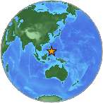
Map not so scale obviously...
Imelda still has Bermuda in the crosshairs and it has a Hurricane Warning up and they are expecting landfall. Bermuda is a wonderful island that is built for Hurricanes, they are no stranger to hurricanes and yet if the forecast verifies then this could be a bigger than usual hit vs one just cruising by offshore. There are some questions in the forecast, as discussed by the NHC in their recent advisory. How strong will Imelda become, she is currently forecast to max out at 100 MPH. Personally, I'd say IF she's intensifying vs struggling then she may go higher so keep that in mind. And, the actual movement and interaction between the two storms may alter her track a bit more than expected currently in the current forecast. As Humberto becomes weaker, Imelda becomes stronger. So we have to stay tune for any last minute changes in the forecast, but Bermuda should prepare for a landfalling Hurricane Imelda.
On a personal level, the winds late last night and early this morning picked up where I live. Not a steady wind, but random strong gusts where the wind made actual noise. That doesn't happen here. I stood out on the balcony watching the pine trees dance and smiled thinking "must be a hurricane" and when I went inside and looked at the NHC site........it was indeed Hurricane Imelda. While it's far away offshore at the beaches where surf is kicking up the way it normally does with a NE wind blowing on the beaches.
Down the tropical road............ as I mentioned ........models are modeling putting out possibilities.
The reality is that until Imelda and Humberto leave the room, so to speak, the Atlantic should be quiet for a week or so. That is not to say models are not dreaming up scenarios for trouble in every part of the basin but they are long range and less reliable. While we are moving into October of 2025, the season is "backloaded" and therefore we expect October to be busy and possibly dangerous. Will hurricanes come up from the Caribbean or form close in the Gulf manking landfall or do we have a continued parade of close in systems forming near Florida and moving North as they are allowed by other factors in the atmosphere as the pattern has been this year. In 2025 the old adage "October all over" does not apply as the 2020s have seen very active Octobers.
The basic purpose of hurricanes is to move air from the tropics up towards the poles and late in the season allowing or let's said "aiding" cold air from the poles to flow South towards the tropics. Hurricanes such as Wilma, Matthew or Sandy flip the switch on Winter and cooler air pounded up in the Arctic is released down and that allows our planet to be healthy and not stagnant.

This process is shown perfectly above.
Note at the base of the ET like figure..
..there's a warm, tropical moisture feed.
It's much like a gas line for a car....
As I & H move further away from the tropics.
These lines set up and you can follow them.
Down in the SW Carib there's a "red brick road"
It feeds them, it fuels them.
Once that is gone.
That energy is stuck down in the Carib....
...at some point usually something begins to brew.
If it's a westbound tropical wave that meets up with it.
It can....form into a wicked October Cane.
So far this year the area has been quiet.
Usually it's quiet with El Nino.
We are not in El Nino.
So....
Will it begin to boil up trouble?

Looking at the lower part of the Mimic....
...you can see the flow from East to West.
Tropical Waves.... westbound.
Another scenario is a westbound tropical wave moves up towards Imelda's breeding ground, or Erin or Chantal and spin closer in and ride the Gulf Stream either to landfall or out to sea. It's also possible, but not desired, that a storm can form close in the Gulf near the Yucatan and be lifted up over South Florida by a cold front and then out to sea. Florida gets hit more in October, especially South Florida from the Gulf to the Atlantic, by October storms. This is the way of the world, weather patterns, seasonal patterns and generally we rely on them but at times something changes and surprises us.

Reds and pinks are of more of a concern here.
Green is very low probability.
These go out 120...
...just a vague reminder
Somewhere some model sees a storm out there.
Very few actually form this far out.
But it's an indication where to look.
When NHC posts a yellow circle we pay attn!
If anything unusual happens today I'll update.
I'm not expecting it but ....
...that's why they call them a surprise.
Have a great day!!
Where ever you live........
...hope you find things you can love about it.
Besos BobbiStorm
@bobbistorm on X
X mostly weather, elsewhere whatever
excute any mistakes....
...love the weather but giving me a headache
is what it is.... meds work eventually
it's cooler, it's beautiful
gonna go take a walk
enjoy the music


 English (US) ·
  French (CA) ·