
 4 months ago
125
4 months ago
125
PROTECT YOUR DNA WITH QUANTUM TECHNOLOGY
Orgo-Life the new way to the future Advertising by AdpathwayDisclaimer: This site is not affiliated with the National Hurricane Center, Hurricane Hunters, Storm Prediction Center, or National Weather Service. ALL forecasts herein are the result of my analysis, (to which you will see me at times, insert excerpts from various agencies due to the nature of the importance of the information) and I am solely responsible for the content. As ALWAYS, follow the National Hurricane Center, National Weather Service, and your local Emergency Management officials for emergency decisions. In addition, this is strictly a FORECAST OFFICE. I CANNOT make decisions regarding travel plans, etc. My purpose, is to provide you the information, based solely on information I analyze, and the accuracy of the information at hand of the time of analysis, so you may make informed decisions.
(T. F. “Storm” Walsh)
For those who have donated to my site, your help has been greatly appreciated. If you are not aware, donations to my site help pay for subscriptions to sites I use as well as software updates, which provide all the models and information used in my forecasts. To donate, please click the DONATE button to the right side of the page, or on the graphic of the dog. Any help you provide is immensely appreciated!
DONATIONS ACCEPTED AND APPRECIATED


I will reiterate, my forecasts are based on the available information at the time of analysis, and are only as accurate as the information analyzed and the solutions provided.
Good day everyone!
I will be out of the office on Tue., Jan. 03 for routine appointments at the VA Outpatient clinic.
The Storm Prediction Center does not indicate any severe weather probabilities, for the week. Should a risk be introduced, it will be included in the future synopses.
I will be using the ECMWF model for the main forecast graphics for winter weather forecasts. Over my years of forecasting, I prefer this model, as numerous articles depict the ECMWF to be the more accurate model as compared to the GFS. Here is an excerpt from an article I found:
The ECMWF model’s resolution is 9km or about 5.5 miles. The GFS has a resolution of 25km or roughly 15.5 miles. This resolution is the distance between two points on a grid that the weather model uses. The smaller the number, the better the resolution/quality of a forecast. The European Center for Medium-Range Weather Forecasts (ECMWF) model is another global numerical weather prediction model that is highly regarded for its accuracy. It employs advanced data assimilation techniques and sophisticated numerical algorithms to simulate atmospheric processes. The ECMWF model provides high-resolution forecasts for various meteorological variables, enabling forecasters to make more precise predictions. According to current weather forecasting standards, the ECMWF model is generally considered the most accurate for predicting snowfall totals, often performing slightly better than American weather models like the GFS.
Should a forecast indicate very cold temperatures, or cold snowy weather:

The following link is from the Animal Welfare Act, and provides guidelines for temperatures regarding your animal:
ANIMAL WELFARE ACT
https://www.aphis.usda.gov/sites/default/files/ac-tech-note-temp-req-dogs.pdf
CONUS AND SEUS SATELLITE LOOP

WPC 12Z SURFACE MAP (LINKED TO SURFACE MAP/RADAR ANIMATION)
Based on analysis of MSLP animations from the ECMWF, Satellite loop imagery, and current surface map analysis, an area of low pressure is currently developing NE of the Bahamas area. As this area moves NEWD today, a new center is forecast to develop later this afternoon, just southeast of the OBX off the coast of N.C. As this occurs, this system is forecast to rapidly intensify with current forecast lowest central pressure of approximately 973 mb (28.73 in.). At the moment, I am not expecting any sub-tropical features to develop.
ECMWF MSLP ANIMATION 72 HOUR FORECAST 

A HURRICANE FORCE WIND WARNING HAS BEEN ISSUED
The following is from the NWS Ocean Prediction Center:
Offshore Waters Forecast NWS Ocean Prediction Center Washington DC
951 AM EST Sat Jan 31 2026:
West central North Atlantic continental shelf and slope waters beyond 20 nm to 250 nm offshore, including south of Georges Bank from 1000 fm to 250 nm offshore.
Seas given as significant wave height, which is the average height of the highest 1/3 of the waves.
Individual waves may be more than twice the significant wave height. Locally higher winds and seas can be expected in and near tstms.
ANZ830-010530- Currituck Beach Light to Cape Hatteras to 100 NM offshore
951 AM EST Sat Jan 31 2026
…HURRICANE FORCE WIND WARNING…
TODAY…NE winds 30 to 40 kt. Seas 10 to 17 ft. Chance of rain.
TONIGHT…N to NE winds 40 to 50 kt, becoming N 55 to 65 kt. Seas 13 to 22 ft, building to 18 to 33 ft. Chance of rain early, then numerous showers. Vsby 1 NM or less.
SUN…N winds 55 to 70 kt, becoming NW 35 to 45 kt. Seas 18 to 33 ft. Rain with vsby 1 nm or less. Scattered showers.
SUN NIGHT...NW winds 30 to 40 kt. Seas 14 to 24 ft. Scattered showers.
MON…NW winds 25 to 30 kt. Seas 10 to 17 ft.
MON NIGHT…NW winds 15 to 20 kt. Seas 7 to 12 ft.
TUE…W winds 10 to 15 kt. Seas 4 to 8 ft.
TUE NIGHT…W winds 10 to 15 kt, becoming 10 to 20 kt. Seas 3 to 5 ft.
WED…W winds 15 to 25 kt. Seas 4 to 7 ft.
WED NIGHT…N to NW winds 10 to 15 kt, becoming N 15 to 25 kt. Seas 4 to 7 ft.
Surface winds could possibly reach 60 mph along the coast, with gusts to 70 – 75 mph possible. This could change, depending on the actual intensity attained by the storm.
CURRENT ECMWF SURFACE WIND AND WIND GUSTS FORECAST 


Seas are currently forecast to reach 8 – 10 ft close to the coast (10 – 14 ft along the OBX) and 25 – 30 ft well offshore. Individual wave heights could reach 16 – 20 ft along the OBX, and 40 – 50 ft. well offshore.
ECMWF SIGNIFICANT WAVE HEIGHT AND DIRECTION FORECAST
ECMWF MAXIMUM INDIVIDUAL WAVE HEIGHT FORECAST
This system will also be responsible for more snowfall over portions of the TN Valley, Mid Atlantic region and a portion of the NE. Some very isolated freezing rain and sleet are also possible.
ECMWF 3 DAY KUCHERA SNOWFALL TOTALS
FREEZING RAIN
SLEET
Residence within the area of onshore wind flow could experience some minor coastal flooding and possible minor beach erosion. I recommend small craft remain in port, and residence remain away from the water during this event. It is recommended that commercial shipping remain alert and avoid the area if possible by taking evasive action.
I will not be posting tomorrow as the office will be closed. Please reference the NWS WATCH / WARNING display map below for any updates to your area.
The following links will connect you to the Excessive Rainfall probabilities and River Flood Outlook:
EXCESSIVE RAINFALL
https://www.wpc.ncep.noaa.gov/qpf/excessive_rainfall_outlook_ero.php
SIGNIFICANT RIVER FLOOD OUTLOOK
https://www.wpc.ncep.noaa.gov/nationalfloodoutlook/index.html
NSSL WINTER STORM SEVERITY INDEX FORECAST (DAY 1 – 3) LINKED MAP
The following NWS Watch / Warning map will provide local NWS information for your area. Click the image, then once it refreshes, click on your area of interest to view any forecasts, watches / warnings, special weather statements, hazards or advisories for your area.
NWS WATCH / WARNING DISPLAY (LINKED…CLICK MAP, THEN YOUR AREA)
NWS DOPPLER RADAR LOOP (LINKED, CLICK RADAR MAP)
RAP RADAR (CLICK IMAGE THEN GO TO LOOP DURATION AND PICK LENGTH OF LOOP, THEN CLICK RADAR SITE)
WUNDERGROUND RADAR SUMMARY MAP (CLICK FOR UPDATES)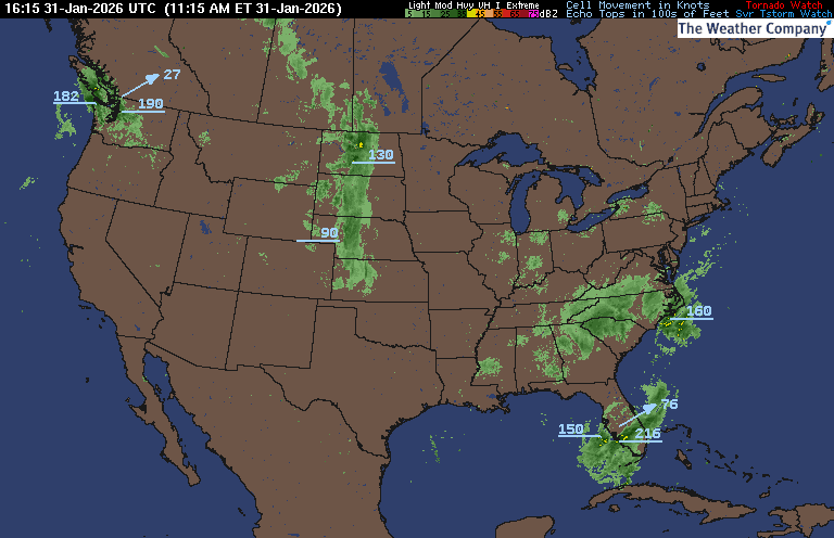
PRECIPITATION TYPE (CLICK TO ACCESS ANIMATION FEATURE)
CARIBBEAN RADAR (CLICK IMAGE TO ACCESS ANIMATION) You may direct any questions by contacting me personally, ANYTIME, at: [email protected]
Have a blessed day!
T. F. “STORM” WALSH III GMCS, USCG (ret)
METEOROLOGIST / HURRICANE SPECIALIST /SEVERE WEATHER SPECIALIST
MEMBER WEST CENTRAL FLORIDA AMS


 English (US) ·
  French (CA) ·