
PROTECT YOUR DNA WITH QUANTUM TECHNOLOGY
Orgo-Life the new way to the future Advertising by Adpathway
Let's start at the beginning with facts.
Currently Orange 60%
Next would be red.
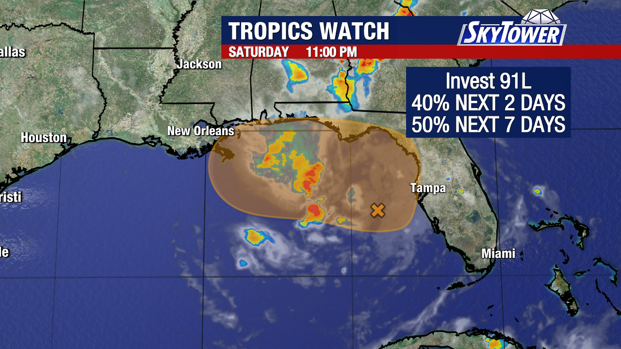
Watch to see
what NHC does at 2 PM.
Zone of formation similar.
Been nudged a bit to the Soth.
Barely touches Hispaniola
Just South of PR
Earlier cone was higher.
Still takes up most the Carib.

Black & white shows the facts.
98L moving into the Islands NOW
(so we can eliminate it forms before Islands...)
Wave close to Africa not exciting.
Old front... new front.
Bit more a tropical disturbance....
...then just a tropical wave.
Yet...not yet a TD.
Is an Invest....
From Mike's wonderful website.

Again models bunched into 3 currently
Lazy today staying with Mike's site

He just makes it so easy.
Intensify forecasts diverse...nothing Major today.
Models change often, check back...
That's a rule of thumb.
Models imagery is just a moment in time!
There's definitely something there...."there"
Front shows up well on satellite imagery.

2 things here.
It's trying......
Note on the left side there's shear.
Oddly as if it's June or July.
So So 2025....
I really believe today is a big day for Invest 98L or let's say the next 24 hours. There are tracks we can eliminate (in theory) based on where it is, how strong it is and going through the Islands we have excellent radar and first hand weather reports. See how low it stays. The lower it stays the more it becomes a stalled out player in CAG area or it slams into Central America on it's way elsewhere. Again, often the end is similar to the beginning, the beginning of the season every good looking wave held it's breath through the Carib and tracked into the EPAC where it got crowned with a name. And, that's one reason there was no development in the Carib....it all cruised into the EPAC.
Some thoughts from X

Can see where 2 could verify.
End of season often like the beginning.
Wave after wave went into EPAC
Seeded storms there.....
...that did not form in the Carib.

Hurricane History...2012 Sandy.
Busy year, this is not a busy year!
People be whispering tho...
Can't rule out long term trouble.
Hoping 3 does not verify... many problems.
Prefer not to mention the storm....
....ppl all screaming or trying not to say.

NOAA EAGLE model....
...weaker westbound.
My thoughts?
Basic as possible.
Weaker tends to go West usually.
Stronger more likely to turn faster.
Being clear here, the GFS has done Hispaniola wrong often showing it moving in that area, big wet storm, stalling out over Hispaniola (that happens when steering currents collapse often between frontal passages) and if that happened it would be misery ala death by flash floods for many in small villages in the mountains. Terrain + Rain = Pain. Also could have problems along the coast, IF the GFS were to verify. So my prayers go to Hispaniola that doesn't happen, would prefer a Mona Passage out of the Carib vs a Windard Passage.

This map shows the 3 passage ways out of Carib.
Straits of Florida near Florida....
Windward Passage between Cuba and Haiti
Mona Passage between DR and PR.
Often they just slam into Cuba or Hispaniola.
aka Great Antilles.
Bottom Line:
Don't know yet.
It's still forming.
Models always best with a real center.

Earthnull is good to verify what you see elsewhere.
No real defined center.
Again toss out the "forming early by Islands"
Orange area in EPAC with good circulation.
Front really diving down.
A tropical wave... Easterly Wave.
Invest 98L still an Invest.
Models still spitting out solutions....
So far stick with the ones that stayed slower.
Slower development after the Islands
Stormy in the Islands....
...but not a named storm.
I have a busy day today. I've got a party to go to in the afternoon so I'll be checking Tropics and football scores on my phone frequently. I really hope Hispaniola does not get 3 feet of rain, or whatever GFS was trying to sell. I really hope "it" stays away from South Florida (really, really, really have a personal reason) and yet hoping and wishing does not make things happen. They play out the way they play out in real time. And, models offer different solutions every model run.
Will update later this evening.... Cool and beautiful this morning in Raleigh, warming up to way to hot this afternoon. Weather report from Miami or as locals call it MyAmi inform me they have only a few hours of possible sunshine vs rain so they are staying near the house at the pool vs the beach. (Beach is less than a mile away) It's cute she finally figured out how to use a Weather App and read the radar! :)
I looked at Mr. Weatherman before hitting "send" with this post to see if I missed anything. Again weather is location and priorities differ depending on their location. He does the Caribbean so he worries on Caribbean Islands. If a storm is up in the Gulf I will use a Cajun Weatherman as they are watching carefully their own back bayou! For an East Coast hit I may follow a Weather person ;) who is watching out for no remakes of Sandy come Halloween!

This is interesting.
This screenshot shows water temps.
Note they are hottest near Jamaica.
More "Ocean Heat Content"
vs down in the cradle of CAG
Though what forms there moves up there.
From warm enough to hot hot hot.
Add in this I remembered to show.

7 day rain forecast.
Note it's all down SE of Florida
(we can hope)
Big storms in NW as I showed last week.
They keep on rolling in...
Rain (green) across the SE.
Check back later.
Sweet dreams of whatever you desire.
BobbiStorm
@bobbistorm on X
Good Song for late October ;)


 English (US) ·
  French (CA) ·