
PROTECT YOUR DNA WITH QUANTUM TECHNOLOGY
Orgo-Life the new way to the future Advertising by AdpathwayThere are San Andreas faults in many places. They happen where two rigid continental masses slide past each other at fairly rapid pace. The San Andreas fault separates (‘connect’ would be the wrong word) the American plate from the continental edge of the Pacific plate. It runs along the length of California, in-land up to San Fransisco and along the coast further north, a distance of almost 2000 kilometer. The fault has grown longer over time: the northern section began to form 30 million years ago, while the southern section is only 5 million years old. It is this southern section that is currently most at risk of a major earthquake. (This is not the ‘big one’ expected further north, by the way: that is the Cascadia subduction zone while the San Andreas is a transform fault. Subduction earthquakes are a different beast.) The slip rate along the San Andreas is around 35 mm per year. In some places it ‘creeps’ which means that the fault isn’t locked, but in other places it is thoroughly stuck. In the south, there may be as much as 9 meters of pent-up movement. Palmdale, beware.
There are San Andreas faults in other places. The way to find them is to look for fast transform (strike-slip) movement in places with a record of major (magnitude 7 to 8) earthquakes. One such place is South Island in New Zealand. The Alpine Fault runs for 600 km along and through South Island with a movement of around 30 mm/year in the southern and central parts (much less in the north). The most recent major earthquake occurred around 1717, and the recurrence time is estimated at 300 years. I just mention it. Christchurch is 100 km away. Hopefully that will be far enough.
There are more. Canada has the Queen Charlotte Fault, 700 km long, with a motion of 50 mm/year. It has magnitude-7 earthquakes about once every 15 years. The 1949 earthquake ruptured a length of 500 km. (America: are you sure you want to claim a country with such a fault, when you already have a major fault of your own? Have you done the risk analysis?) The Chaman fault in Pakistan (800 km) has a slip movement of 10-35 mm/year. It last had a major event in 1935. Myanmar has the 1400-km long Sagaing fault, running through all its major cities. It has a slip rate of 22 mm/year and has a major event once every 15-20 years, with a 100 year recurrence time for each location. The magnitude 7.8 earthquake of 28 March of this year (2025), which destroyed Mandalay, ruptured a length of 570 km of the Sagaing fault.
There some lesser San Andreas faults as well, which can be just as dangerous. The devastating Gantziap earthquake on 6 February 2023 occurred on the East Anatolian Fault, where slip rates are 3-10 mm/year. The Dead Sea Transform fault which is connected to the East Anatolian Fault slips at around 4-5 mm/year. After a long quiescence since the Middle Ages, a large earthquake on this fault would not be unexpected. The Great Glen fault in Scotland was off the same type, as shown by the large offset between the land north and south of the line. (This fault continues on the other side of the Atlantic into NewFoundland. It hosts Loch Ness, and is thereby the only fault one the world warranting the name ‘monster fault’.) But in spite of an occasional tremor, it is safely extinct, so no worries there.
These faults have some common aspects. They tend to be relatively young, typically 5-20 million years. They are segmented, where each segment can fail separately from the others. The largest events happen when two or more segments fail simultaneously. Although the faults tend to be very active with frequent earthquakes, each segment has a recurrence time measured in centuries. That means that living memory is lost and each earthquake comes as a surprise: the earthquakes seemingly are always ‘somewhere else’ and there seems to be no need to take precautions in your own town. This can make them costly – both in capital and in human terms.
The most San-Andreas-like fault is the North Anatolian fault which runs for 1200 km along the northern length of Turkey and is in the process of extending itself towards Greece. It has had 12 major earthquakes of magnitude 6.9 or more since 1930! This may not be normal: it has been exceptionally active over this time. Many of the cities along this fault line were hit, from Erzincan in 1939 and Gerede in 1944 to Izmit in 1999. Only one main city has escaped so far. Istanbul.
But for how much longer?
The Fault

Source: Caglayan et al. 2018. (This map assigns much of Greece to the Anatolian plate. More common is that the Anatolian plate is shown terminating in the Aegean Sea.)
Turkey forms a microplate which is squeezed between the Arabian plate, the African plate and the Eurasian plate. Its only way out is west. Almost the whole country moves west, at a rate of around 20 mm/year. This movement is mainly accommodated by the North Anatolian Fault (NAFZ on the map) which separates the Anatolian plate from Eurasia. The northernmost part of Turkey lies on the Eurasian plate, and this includes its best known city, Istanbul.
In the west, Greece is forming a barrier and here the Anatolian plate in a moment of conflict avoidance rotates towards the southwest. The physical reason for this is that the subduction zone in the Mediterranean Sea is rolling back southward, and this creates space for Turkey to move in to. In the western region where Turkey begins to rotate, the fault structure becomes more fragmented but the North Anatolian remains the main mover and shaker. And it moves and shakes a lot, as mentioned above.
The Magnitude March
In 1997, Stein, Barka & Dietirich drew attention to an earthquake sequence that had been going on for 60 years. These earthquakes were all along segments of the North Anatolian fault. The list and map is reproduced from their paper below.

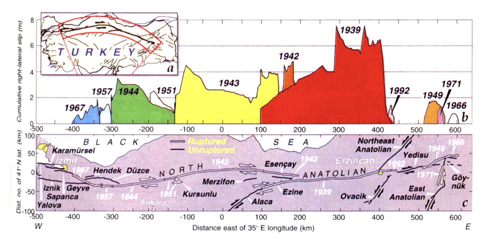
The sequence originated in the east with the very large 1939 earthquake which hit the city of Erzincan. A 350-km long section of the fault broke. This was mid-winter with temperatures well below freezing. Aid took long to arrive. Some 33,000 people died in this devastating event. In 1942, a small section at the western side of the 1932 fault. This turned out to be a prequel: a year later a much larger, 280-km section broke to the west. This was followed in 1944 by the next section, around the town of Gerede. In total, over these 5 years a section of 700 km of the North Anatolian Fault had ruptured.
In 1949 an earthquake occurred much further east. Although on the same fault, this was not related to the previous sequence. In 1951, a small gap in the previous sequence was filled in. The sequence continued a few years later, when in 1957 and 1967 the next two segments to the west ruptured, adding another 100 km to the rupture.
Stein et al. showed that each of the quakes had increased the stress on the next segment, and thus had caused the next earthquake to happen earlier than would otherwise have been the case. In some cases the time acceleration was fairly minor. The 1943 earthquake had been very little advances by the stress change: it ‘just happened’, unrelated to the precursor. But the 1944 earthquake was brought forward by some 30 years. The 1957 and 1967 events also happened 30 years earlier than would otherwise have been the case.
In 1997, the authors found that the stress had been transferred to two sections: one just to the west of the 1967 quake, and one to the east of the original 1939 earthquake.
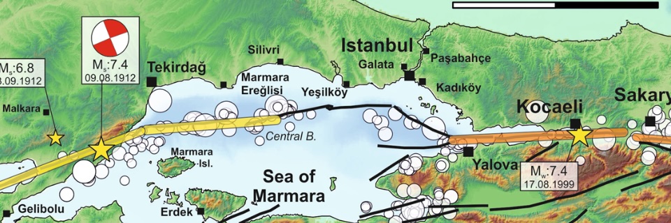
Just two years later, the western segment of these two ruptured, in a double earthquake in August and November 1999, which devastated the city of Izmit.
And here the march of the earthquakes ended. The fault further southwest (in the Dardanelles) had a massive double rupture in 1912, and it is not ready to fail again, at least not in a large event.
But there remains a gap. One section is left unruptured, in between the 1912 and 1999 events. And this segment, which may be the last step in the magnitude march, comes to within 20 km of the city of Istanbul.
The Fault and the Marmara Sea
Between the Black Sea and the Aegean Sea lies a much smaller body of water. This is the famous Marmara Sea. It is connected to the Aegean Sea by the Dardanelles Straits and to the Black Sea by the Bosporus. Both are natural waterways. If you are interested, and this is really the only volcanic connection in this post, the name Bosporus originally referred to a cow. The name translates as ‘ox ford’. If you are now in serious doubt how this is volcanic, it comes from Greek mythology. The story begins with Io, a princess who (unwisely) became involved with Zeus. Hera, Zeus’ wife, took exception to this (no surprise there) and turned Io into a white cow (that was more unexpected). She also imprisoned the cow Io, just to make sure. However, Hermes managed to set her free (another story). Hera now resorted to sending a fly to sting Io continuously, in order to keep her moving, presumably away from Zeus. Eventually cow Io forded the Bosporus towards the Caucasus. That crossing is the origin of the name Bosporus. Io eventually regained human form, and later one of her grandsons, Byzas, founded Byzantium – the Greek settlement that became Istanbul. Io, of course, also gave her name to the most volcanic body in the solar system – and that will have to do for the volcanic connection.
(The spelling Bosphorus which is sometimes seen is incorrect.)
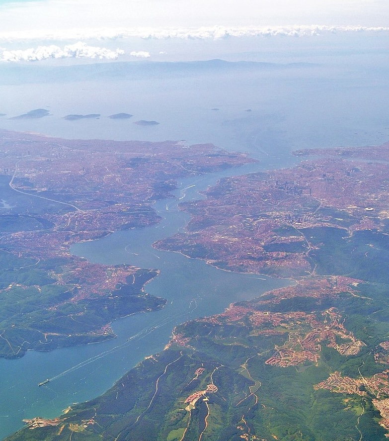
The Bosporus, with the Marmara Sea and the Kizil Islands in the background and the city of Istanbul along the shoreline. Source: Wikipedia
The origin of the name ‘Marmara Sea’ is rather more prosaic, albeit also Greek. It is named for its marble, which was found on islands in the southwest part of the sea. The Marmara Sea is 280 km long and 80 km wide. Although much of the sea is fairly shallow, it also contains a long trough which reaches 1350 meter deep.
The reason that the sea is here lies in the North Anatolian Fault. Here is where the Anatolian plate begins to rotate towards the south. The fault line still runs fairly straight, but Turkey bends away. The Anatolian plate therefore pulls away from the Eurasian plate along this fault line. The Marmara Sea is this pull-away basin, and the trough follows the fault line.
The North Anatolian Fault runs through the narrow Gulf of Izmit at the eastern end of the Marmara Sea, comes close to Istanbul airport, and then runs past the Kizil (or Princess) Islands, staying closer to the northern shore. Only further west does it begin to bend towards the southwest.
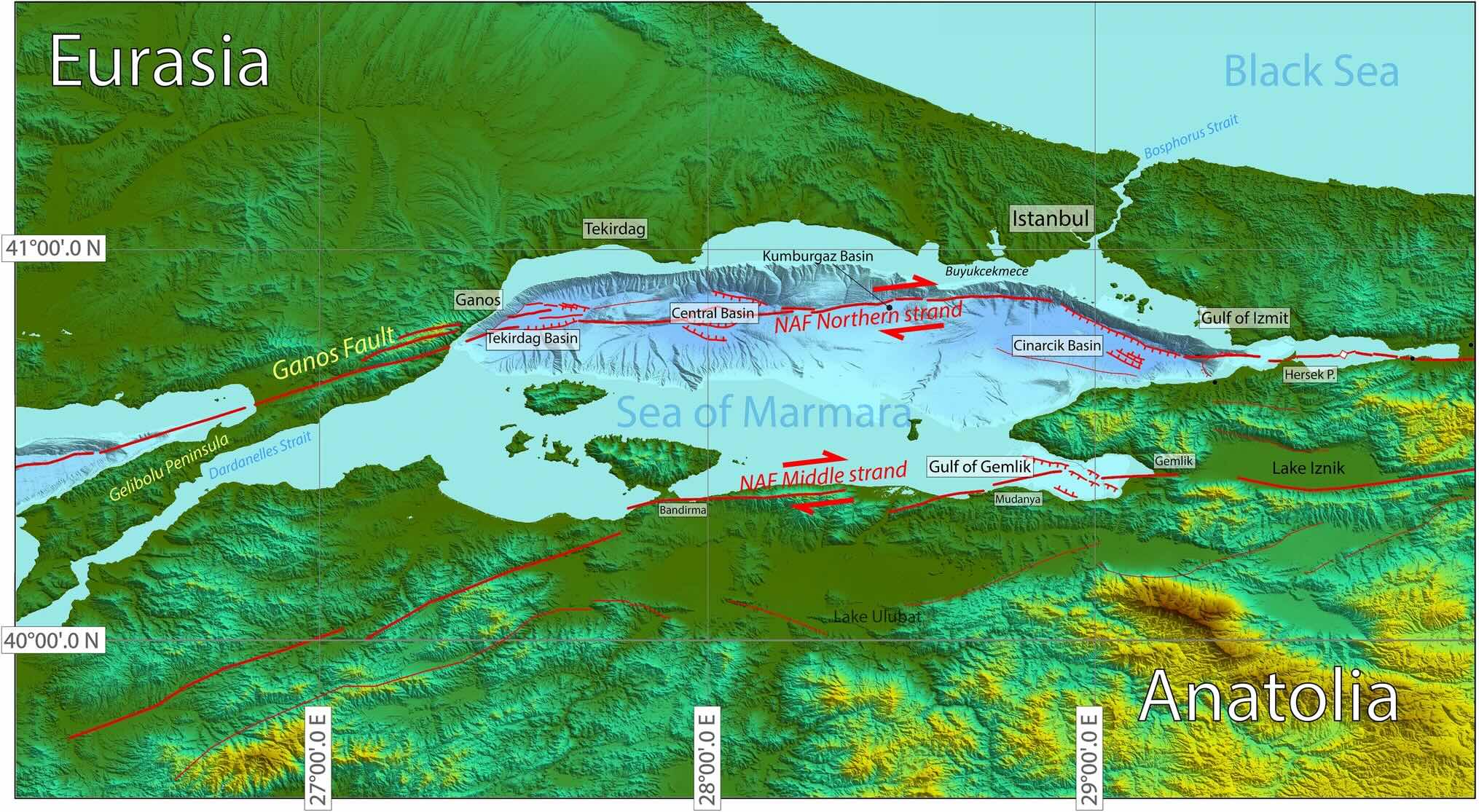
The Marmara Sea has developed three deep basins in its northern half, along the northern strand: from east to west these are the Cinarcik, Central and Tekirdag basins. The basins are around 1.2 km deep, separated by ridges only around 300 meters higher. Between the Cinarcik and Central basins is a larger area which is considered a separate, fourth basin (Kumbargaz basin) but at 900 meter deep it has the same depth as the ridges. The southern part of the Marmara Sea is much shallower.
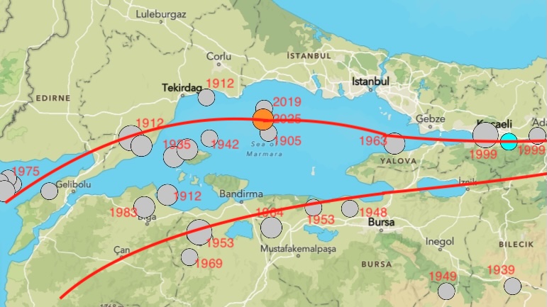
Earthquakes in the Sea of Marmara stronger than M5.5 since 1900. Source: USGS. The fault lines are indicated only roughly and the locations of the earthquakes are approximate.
Faults of the Sea
There are two North Anatolian Faults in this region. As mentioned, the main one runs within the Sea close to the northern shoreline, and accommodates around 20 mm/year of movement. The second one runs along the southern edge of the Marmara Sea, with a movement of around 4mm/year. There is also extension at some 8 mm/yr (the pull-away movement which formed the Marmara Sea) which is accommodated mainly by the second branch.
This a simplified description: In reality the faults are segmented, where the segments are not always aligned and sometimes even run parallel. The main fault is still quite young in this region and hasn’t fully organised itself. The North Anatolian Fault hasn’t made up its mind where it wants to go. Westward-go – but which route? The northern strand is the dominant one at the moment, based on GPS movements.
The northern strand of the fault is called, unsurprisingly, the northern strand. The southern one is called, a bit more surprising, the middle strand. There is indeed a third one that runs further south and is called the southern strand, but it is a wider fault zone rather than a single fault, with many parallel segments running towards the Gulf of Edremit. It is sometimes called the Southern Anatolian Fault.
These faults are responsible for the earthquakes. A map of the stronger earthquakes since 1900 is shown above, with the year of the events. From this, it seems that southern (middle) strand has been more active, but note that it includes a cluster of earthquakes around 1950. The northern strand had the major events of 1912. After that, there were few events until 2019.
In 2019, an earthquake hit the central part of the Marmara Sea. And now, in 2025, there was a second one, not far from the 2019 location. This earthquake caused some damage in Istanbul. And it reignited the fear of a larger earthquake, the missing step of the march. That is not an unreasonable fear. In fact, there was a similar earthquake here in 1905, 7 years before the major rupture of 1912. Was that coincidence, or was there a link? The jury is out.
The fact that the fault is submerged and segmented makes it hard to study. We don’t know exactly which sections failed in which earthquakes, nor how large the failure was. Tye most recent major failure in the region occurred on the western side of the Marmara Sea. That was in 1912.
The 1912 earthquake
On 9 August 1912, a few hours after midnight, the region between the Gulf of Saros and the Marmara Sea was hit by an earthquakes estimated at magnitude 7.3. There had been a number of foreshocks over the preceding two weeks. The segment of the North Anatolian fault that connects the two seas is called the Ganos fault. It continues into the Gulf of Saros as the Saros fault, and on the other side extends into the Tekirdag basin of the Marmara Sea. On land it forms a 45-km long, narrow valley.
This was one of the largest earthquakes known to have hit the Balkan: it was felt as far as Vienna. There are still features and roads in the region that show offsets of 4.5 to 5.5 meters, caused by this event. But these were hard times with war brewing (the Balkan war would break out in October, and the event did not receive much attention at the time. Some 2800 fatalities were reported but there are no accurate accounts. Many towns and villages in the region were destroyed.
There was a second earthquake on 12 September 1912, estimated at magnitude 6.8. This is larger than a normal aftershock and it is considered an event in its own right. This quake collapsed some buildings that had been damaged in August. It probably ruptured the segment immediate west of the first earthquake, into the Gulf of Saros.
Together, the two earthquakes ruptured a length of 100 to 150 km. It extended for some 20 km into the Gulf of Saros. As the on-land segment is 45 km, this means the rupture must have extended well into the Marmara Sea. There is evidence for this. Turbide deposit from this event have been found in the sea, and reports from the time report tsunami-like waves which could have been caused by such a submarine landslide.
The rupture likely extended into the Tekirdag basin and possibly the Central basin but no further. The sets the western end of the seismic gap. The eastern end comes from the Izmit earthquakes which extended some 20 km into the eastern end of the Sea. That leaves an unruptured segment of around 100 to perhaps 150 km.
Source: Aksoy, Mediterranean Geoscience Reviews (2021) 3:95–114 (sorry – paywalled: reading not allowed.)
Recurrence
The offset of 5 meters compared to the movement of 20 mm/yr suggests a recurrence time of 250 years. So when were the previous earthquakes? Is the recurrence time of 250 years common along the North Anatolian fault?
This is not so easy to determine. For historical earthquakes, both the size and precise location may be uncertain. For the region of the Marmara Sea, there were no large quakes (M7+) in the 19th century but there was a significant one in the Gulf of Izmit in 1894. The most recent large event in the area of the 1912 earthquake was in August 1766, at magnitude 7.5 (estimated, of course) along the Ganos fault. This does not fit well with the 5.5 meter slip observed in 1912 which would have needed another century to build up. A plausible explanation is that the larger 1912 earthquake ruptured the segment east of the August 1766 earthquake, and only the smaller 1912 event was on the 1766 rupture. The smaller event was smaller because it had built up less stress since the last slip. The 250 year recurrence time should not be taken with absolute confidence!
The map below shows the main events since 1500. It shows two gaps, on the northern strand in the eastern half of the Marmara Sea which last ruptured in 1766, and on the middle strand below the Gulf of Izmit which last went in 1719.
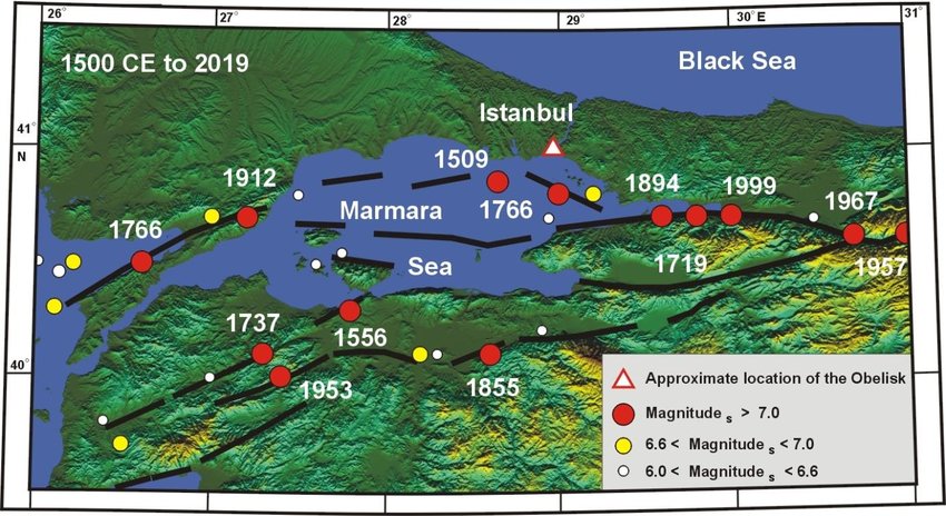
Original source: Ambrasey and Jackson, 2000
The historical record goes back a millennium further, to the founding of Constantinople in the year 330. But the descriptions are sketchy and make it difficult to separate the major from the moderate events, or to decide how far from the city the epicentre was. Here is my selection. Note that the name change to Istanbul occurred in 1453 (but was made official only in 1930).
Istanbul/Constantinople major earthquakes
22 May 1766
The most recent major earthquake which impacted Istanbul directly was in May 1766. It had an estimated magnitude of 7.1. The epicentre was probably around the Cinarcik basin, just south of Istanbul, although this is not certain. There were some 2000 fatalities, of which around 800 were in Istanbul itself.
It was followed by the even stronger destructive earthquake (M7.5) in the Dardanelles in August. That event did little damage in Istanbul.
A common feature of these two earthquakes was that masonry building would collapse but half-timbered buildings would remain standing, albeit with damage. The same had been seen in Lisbon 11 years before. In Lisbon, the rebuilding was done to more stringent building standards. That was not the case in Istanbul where the rebuilding was much less regulated.
1509
On 10 September 1509, some 50 years after the city had been conquered in 1453, it was hit by a devastating earthquake. This became known as the ‘minor judgement day’, referring to the tradition that an earthquake will accompany the last judgement. Some 5000 people died and reports state that not a single building in Istanbul was left undamaged. What remained of the old walls collapsed. The Sultan escaped death when his bedroom collapsed shortly after he had left.
This was worse than the later 1766 event. It was likely an magnitude 7.2+ event, with an epicentre also in the Cinarcik basin.
1343
On 18 Oct 1343, there was major destruction in Constantinople, with damage to the city walls and Hagia Sophia. Turbide deposits found in the Central Basin are dated to this event. They show that the earthquake was large enough to cause large slides in the basin, and this makes it likely it was one of the major events. No turbide deposits have been found in the Cinarcik Basin, but the record there does not go far enough back for this.
989
There was widespread damage in the region and the western dome of the Hagia Sophia collapsed. The earthquake was felt as far away as Italy, but the precise location of the epicentre is not known.
740
On 26 Oct. 740, a large earthquake hit Constantinople. This again was large enough that turbides have been seen in the Central Basin.
14 December 557
This was only 15 years after the disaster of the Justinian plague. There had been two earthquakes that year earlier that year which had done little damage. The third was much worse. It struck just before midnight. Agathias Scholasticus wrote that Constantinople was almost leveled to the ground.
The air was full of dust and people were afraid to enter buildings or churches. As an interesting aside, Agathias writes that a large number of women of all social classes went beyond social decorum and consorted even with men of lower status. The earthquake not only leveled buildings, it leveled social distinctions as well. Some of the city walls were destroyed and the Hagia Sophia was damaged. The state of the city, after having lost a quarter of its population to the plague, was such that few repairs were done. On 7 May 558, an aftershock collapsed the eastern half-dome and part of the main dome of the Hagia Sophia.
This event is also notable and that it coincided with the largest extent that the Eastern Roman Empire reached. After the Justinian plague the wars of expansion had resumed although with greatly limited man power as so many people had died. (That was true for both sides in the battles.) One can speculate whether this earthquake had a role in the contraction of the empire that followed.
The city has been affected by many more reported earthquakes. For events which occured before the 19th century, it is difficult to separate the major ones from earthquakes that were moderate or had an epicentre further away. Here are some events that caused damage in Istanbul but seemed smaller or more distant:
1894 This was a large magnitude 7.3 earthquake which occurred along the Gulf of Izmit. It was far enough from Istanbul that there was little damage in the city but to the east the damage was serious. It probably ruptured the fault that runs along the southern side of the gulf of Izmit, on the ‘middle strand’.
1855 A magnitude=7 quake occurred south of the Marmara Sea in the region of Bursa, on the middle strand. It caused minor damage in Istanbul but was felt widely in the region. The city of Bursa itself was severely damaged.
1841 This event has been assigned a magnitude 6.1, and so is not one of the large shakes. Still, it caused some damage in Istanbul, with the collapse of minarets and parts of the wall. A report states “ many walls were demolished opposite Kazgancilar on the Mercan side of the Serasker Gate. Ten offices were demolished on the inside of the thorough fare of the han at the head of Kalpakcilar. The walls of 12 rooms on the middle floor of the Kebleci han; two rooms on the ground floor were demolished opposite Vezir Han; in the upper part of Yarim Tas Han, the walls of five rooms and the porch and the doors alongside were split; the walls of two rooms on the ground floor and five rooms on the upper floor of the Yaglikci Han in Tavukpazari were split. Some of the walls of five rooms in the Nakbecbi Hani were also split; the walls of three rooms were cracked in the Tas Han wineshop in the area of the Kucuk Tas Han” (Ambraseys 2000, Journal of Earthquake Engineering, Vol. 4, 377 (paywalled).
869 This event is notable because of the collapse of churches. It is known as the ‘great earthquake of the reign of Basil I’. It followed another damaging event in 866
Intervals
The record does not seem to support a regular interval of 250 year of major earthquakes in Istanbul. This time difference exists between the 1509 and 1766 events, but the medieval earthquakes have intervals between 150 and 350 years. In fact, the interval between 1766 and 1894 is even shorter. The segmented nature of the fault may complicate the patterns: a short interval may be because the earthquakes occurred on different, adjacent segments of the fault, and sometimes a neighbouring segment may trigger an early release of the stress, causing a smaller and earlier event. Purely based on historical intervals, the next major event could be as late as the end of this century. Or it could have happened a century ago.
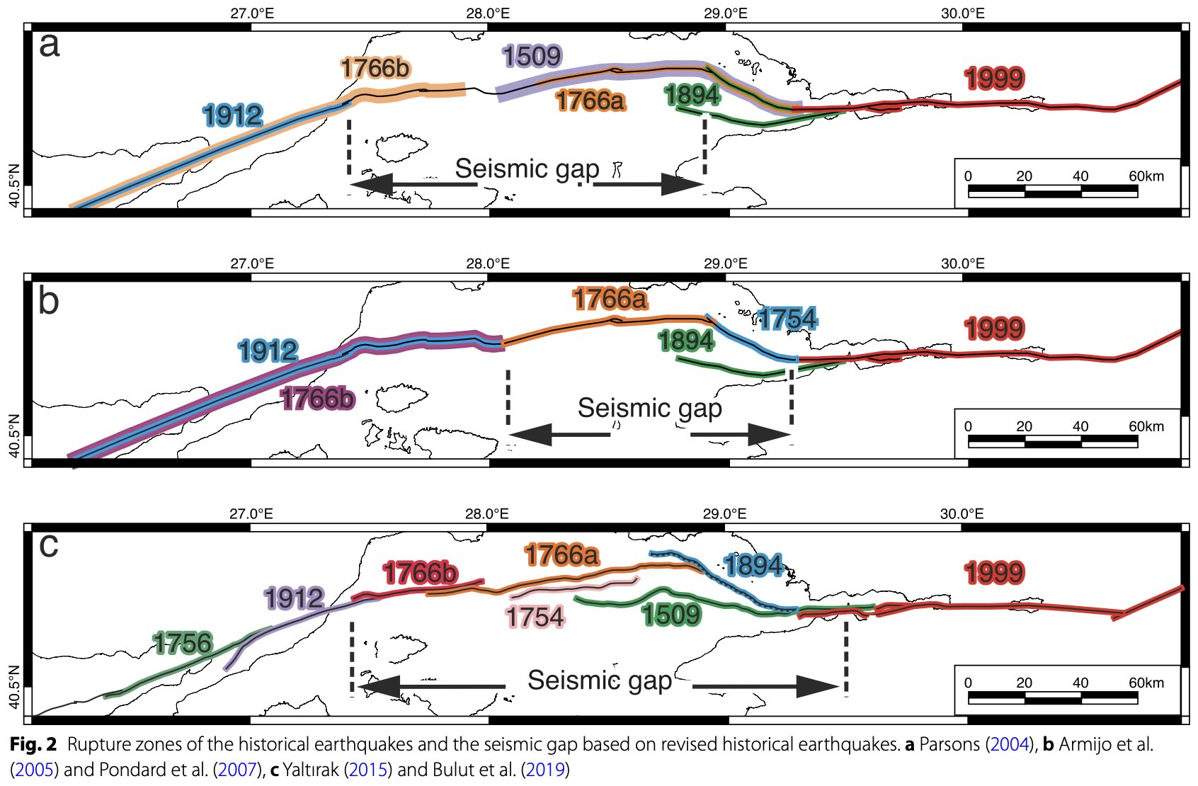
Combining the more recent earthquakes, Sahin et al (2022, Earth, Planets and Space, 74, 167) show three possible maps for which segments belong to which earthquakes. These leads to three different sizes of the unruptured gaps! The middle option (panel b) appears most likely.
The 2025 earthquake
On 23 April 2025, Istanbul was hit by a magnitude 6.2 event. The epicentre was at the eastern end of the Central Basin, probably at the end of the rupture zone of 1912. The epicentre was around 70 km from the city. A few hundred injuries were reported and there was damage to some houses.
The same region was also struck on 26 September 2019 with a magnitude 5.8 event, which also caused some minor damage in Istanbul. This event had been a surprise as it was not centred on the main fault and no fault had been known at the location of the epicentre. Sahin et al (mentioned above) have found indications for buried faults along the ridge that separates the Central and the Kumbargaz basins, called the Silivri Ridge. One of the these, called (of course) the Silivri Fault, caused the M5.8 earthquake. They calculated that the event increased the stress on the other faults in the region. It is probably one of those which failed in April. Whether this was another ‘secondary’ fault or the main one is not clear at the moment. The M6.2 size is within range of the secondary faults but the location seems close to the main fault.
The secondary faults are very poorly known. There are many of them, but they have much longer recurrence times than the main fault. So every event there comes as a surprise.
What does this mean for Istanbul? The optimistic view is that the M6.2 event occurred on the main fault and released some of the stress on the seismic gap. The pessimistic view is that it is a foreshock to the main event. The neutral view is that it occurred on a secondary fault and has little impact on the main fault. The optimistic view seems unrealistic. There is enough built-up stress for an M7 to M7.2 earthquake. An M6.2 carries only a few percent of that energy and so has little effect. The pessimistic view is based on the fact that foreshocks are not uncommon for major ruptures along the North Anatolian Fault. It also assumes that the seismic gap in the North Anatolian Fault is ready to go and that the event added stress to it. The neutral view is, well, neutral.
There are knowns and there are unknowns. Istanbul is located near one of the most dangerous faults in the world, and it has been hit badly several times before. The time since the last major earthquake on the segment of the fault close to the city is now over 250 years. The Izmit earthquake in 1999 caused significant damage and fatalities in Istanbul: a large earthquake much closer to the city would be much worse. So far, so bad.
But predicting earthquakes is risky, and predicting their magnitude even more so. We don’t know how large the locked segment is: it may be much shorter than proposed. It may fail not in one event but in two separate ones on either end, which would reduce the impact on Istanbul. We don’t know how fixed the recurrence time is: it may be longer than thought.
There are reasons for concern. The 2019 and 2025 earthquakes may indicate a growing instability. In history, earthquakes here have often come in pairs with one large event followed within decades by one on the next segment. Foreshocks (in hindsight) have also not been uncommon, as per the pessimistic view. The optimistic view would counter that most earthquakes are not foreshocks, and the neutral view would point out that this is best decided in hindsight.
But the major cause for concern is that the experience with past earthquakes has shown that building standards can be viewed as optional. The catastrophic toll of the devastating 2023 Gantziap earthquake, with 57,000 fatalities, suggests not enough was learned from the destruction in Izmit two decades earlier. If the same is true in Istanbul, then the next event may leave little of the city standing. In a metropole of 17 million people, that could be much worse even than the Gantziak earthquake.
The bottom line is that the April 2025 earthquake is a wake-up call. We don’t know when the next earthquake will be nor how large it will be, but we do know it will happen. It is time to check the resilience of the buildings, and test the emergency plan. Istanbul, Los Angeles, Christchurch: beware. The countdown is on.
Albert, May 2025

At the VC office


 English (US) ·
  French (CA) ·