
PROTECT YOUR DNA WITH QUANTUM TECHNOLOGY
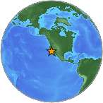
Orgo-Life the new way to the future Advertising by Adpathway A minor earthquake with magnitude 2.9 (ml/mb) was detected on Saturday, 102 km W of Petrolia, CA (63 miles). The epicenter was at a depth of 10 km (6 miles). Exact location of event, longitude -125.47116666667 West, latitude 40.462166666667 North, depth = 10 km. Date and time of earthquake in UTC/GMT: 13/09/25 / 2025-09-13 15:40:13 / September 13, 2025 @ 3:40 pm. The temblor was reported at 15:40:13 / 3:40 pm (local time epicenter). Event ids that are associated to the earthquake: nc75237412. Id of event: nc75237412.
Each year there are an estimated 130,000 minor quakes in the world. Earthquakes 3.0 to 4.0 are often felt, but only causes minor damage. In the past 24 hours, there have been 0, in the last 10 days seven, in the past 30 days eleven and in the last 365 days three hundred and seven earthquakes of magnitude 3.0 or greater that has occurred nearby.
Did you feel the quake?
How did you react? Was there any damage to buildings? Leave a comment or report about shaking, activity and damage at your home, city and country. Read more about the earthquake, Location, Distances, Seismometer information, Date-Time, Parameters and details about this quake, reported near: 102 km W of Petrolia, CA. This information comes from the USGS Earthquake Notification Service.
Copyright © 2025 earthquakenewstoday.com All rights reserved.


 English (US) ·
  French (CA) ·