
 8 months ago
126
8 months ago
126
PROTECT YOUR DNA WITH QUANTUM TECHNOLOGY
Orgo-Life the new way to the future Advertising by AdpathwayDisclaimer: This site is not affiliated with the National Hurricane Center, Hurricane Hunters, Storm Prediction Center, or National Weather Service. ALL forecasts herein are the result of my analysis, (to which you will see me at times, insert excerpts from various agencies due to the nature of the importance of the information) and I am solely responsible for the content. As ALWAYS, follow the National Hurricane Center, National Weather Service, and your local Emergency Management officials for emergency decisions. In addition, this is strictly a FORECAST OFFICE. I CANNOT make decisions regarding travel plans, etc. My purpose, is to provide you the information, based solely on information I analyze, and the accuracy of the information at hand of the time of analysis, so you may make informed decisions.
(T. F. “Storm” Walsh)
For those who have donated to my site, your help has been greatly appreciated. If you are not aware, donations to my site help pay for subscriptions to sites I use as well as software updates, which provide all the models and information used in my forecasts. To donate, please click the DONATE button to the right side of the page, or on the graphic of the dog. Any help you provide is immensely appreciated!
DONATIONS ACCEPTED AND APPRECIATED


I will reiterate, my forecasts are based on the available information at the time of analysis, and are only as accurate as the information analyzed and the solutions provided.
Good day everyone!
This forecast will start closer to home today.
STORM W 2025 SEASON FORECAST
TOTAL NAMED STORMS: 15 – 17
TOTAL HURRICANES: 7 – 8
MAJOR HURRICANES: 2 – 3
AVERAGE HURRICANE SEASON:
TOTAL NAMED STORMS: 14
TOTAL HURRICANES: 7
MAJOR HURRICANES: 3
CSU (Dr. Phil Klotzbach) UPDATED SEASONAL FORECAST
TOTAL NAMED STORMS: 16
TOTAL HURRICANES: 8
MAJOR HURRICANES: 3
2025 HURRICANE SEASON TOTALS
TOTAL NAMED STORMS: 11*
TOTAL HURRICANES: 4
MAJOR HURRICANES: 3
* (10 TROPICAL…1 SUBTROPICAL)
The following is the list of storm names for the 2025 Atlantic Hurricane Season:
Andrea Barry Chantal Dexter Erin Fernand Gabrielle Humberto Imelda Jerry
Karen Lorenzo Melissa Nestor Olga Pablo Rebekah Sebastien Tanya Van Wendy
As we go through the season and storms are named, I will mark them in RED to indicate active, or already named systems.
Please use the following links for severe weather information:
SPC HOMEPAGE LINK
https://www.spc.noaa.gov/classic.html
NADOCAST
http://data.nadocast.com/
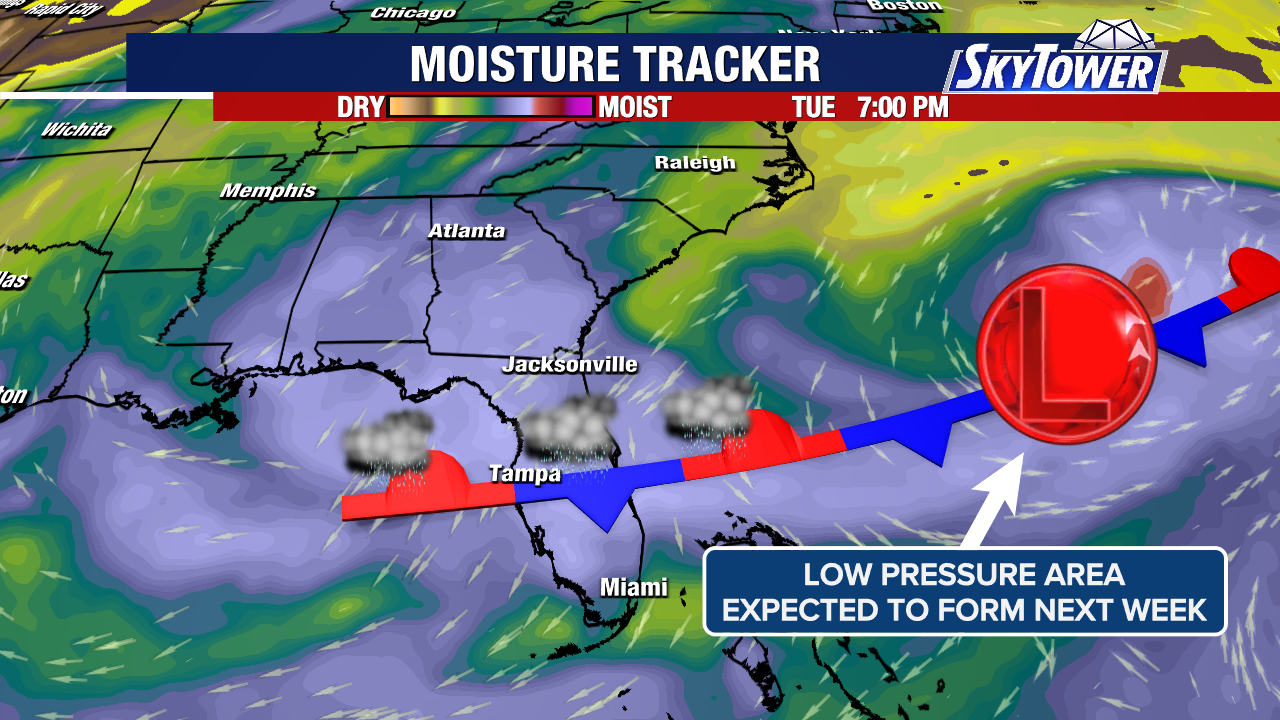
Based on analysis of the current run of the global models surface maps, an area of low pressure is forecast to begin developing in approximately 24 hours IVO over the Florida Peninsula / Northern Bahamas. In fact, based on recent satellite loop imagery, it appears the seed has already been planted:
SEUS SATELLITE LOOP
Based on analysis of MSLP animations fro the ECMWF, GFS and CMC models, the system should emerge over the Gulfstream, and take pretty much of a N to NNE path remaining not too far off the U.S. east coast. A slight change in thermal diagrams tends to indicate once this enters the Gulfstream, that it will be borderline warm core, and upon reaching cooler SST’s further north, will become closer to borderline cold core. Right now, it is unknown as to whether or not this may try to transition to sub-tropical as I’ll have to see how interaction with the Gulfstream affects it. Currently, the low is forecast to be “baroclinic”(extratropical”) in nature based on strong shear remaining over it, and marginal surface to mid level moisture in the forecast. Models indicate a various scenario, where this remains intact, or “splits” into 2 systems. Regardless of whether it transitions or not, I highly recommend residents along the Eastern Seaboard mostly from the Carolinas, northward monitor this very closely, as this system is forecast to produce strong gale force winds with possible gusts to around 60 – 70 mph, localized heavy rainfall, possible significant coastal flooding given the possible slow movement and possible brief stall. Coastal flooding may occur due to the easterly fetch of wave heights near the coast reaching 12 ft, and maximum individual wave heights reaching 40+ feet well offshore. Some power outages cannot be ruled out. I recommend residents remain away from the beaches due to the possible dangerous surf, and small craft remain in port until this system passes.
ECMWF, GFS, AND CMC MSLP ANOMALIES FORECAST ANIMATION


ECMWF SURFACE WINDS AND GUSTS FORECAST

ECMWF AND NATIONAL BLEND OF MODELS TOTAL PRECIPITATION 7 DAY FORECAST
ECMWF SIGNIFICANT WAVE HEIGHT AND DIRECTION / MAXIMUM INDIVIDUAL WAVE HEIGHT

I will continue to monitor this situation very closely during the next 48 – 96 hours for any significant changes to forecast conditions , and if needed, will try to update as necessary.
Elsewhere, Tropical Storm JERRY is now moving to the NW.
TROPICAL STORM JERRY SATELLITE LOOP

As of the 11:00 A.M. advisory from the NHC, the following information was available on Tropical Storm JERRY.
11:00 AM EDT Thu Oct 09
Location: 20.2N;63.4W
Moving: NW 16 mph
Min pressure: 1006 mb / 29.71 in.
Max sustained: 50 mph
NHC FORECAST DISCUSSION LINK
https://www.nhc.noaa.gov/text/refresh/MIATCDAT5+shtml/101442.shtml?
NHC PUBLIC ADVISORY LINK
https://www.nhc.noaa.gov/text/refresh/MIATCPAT5+shtml/101441.shtml?
Tropical Storm Watches have been issued for the following locations:
SUMMARY OF WATCHES AND WARNINGS IN EFFECT:
All watches and warnings have been discontinued
NHC GRAPHICS
 RAINFALL FORECAST
RIP CURRENTS

Based on my analysis of updated forecast steering, JERRY should follow the forecast track guidance, and should make the north turn sometime late today or this evening. Given this, I agree with the NHC forecast track and current track guidance.
TROPICAL STORM JERRY 12Z TRACK GUIDANCE
12Z ATCF GUIDANCE
HURRICANE FORECAST MODEL GUIDANCE
NHC FORECAST TRACK MAP
JERRY continues to struggle, since yesterday evening, with visible satellite imagery indicating the LLC exposed and elongated. Based on analysis of the recent wind shear map from CIMSS, NWLY shear is once again around 20 kts around the center. NHC states in the recent discussion that JERRY continues to head into the shear vector. It is noted that both the global models and SHIPS diagnostics have done a poor job at handling the shear forecast with JERRY, which was forecast to be a favorable pattern and long enough reduction to allow the storm to intensify as previously forecast, hence throwing the forecast off. Though there is a well established outflow jet north of JERRY, this is fairly north of the circulation center. Given that the outflow does not begin near the center of the storm, and is somewhat in a disruptive flow near the center, with weaker outflow south of the center, I believe this is why the effect of the shear has not been negated. Although the current SHIPS update still shows shear not to increase to above 20 kts until approximately 48 hours from 12Z, without the storm slowing any further, and if no improvement occurs with the upper pattern, JERRY will most likely remain a Tropical Storm. Based on the new occurrences, I agree with the NHC updated forecast intensity, however I’m a little skeptical of the 60 mph intensity.
CIMSS RECENT WIND SHEAR
NHC INTENSITY FORECAST
From the National Hurricane Center:
Elsewhere, the low pressure area that was being monitored in the extreme N. Atlantic ocean has transitioned into Sub-Tropical Storm KAREN. As of the 11:00 A.M. EDT advisory from the NHC, the following information was available on KAREN:
11:00 AM EDT Thu Oct 09
Location: 46.3N;31.2W
Moving: NE 13 mph
Min pressure: 998 mb / 29.47 in.
Max sustained: 45mph
KAREN SATELLITE LOOP

KAREN developed over SST’s of only 20C – 21C (68F – 70F). Some of you may be asking how did that happen, since a tropical system requires SST’s of at least 26.5C (80F)? In my research, those SST’s were borderline for development of a subtropical system. The low yesterday was part of an occluded frontal boundary. What had to happen, (and I didn’t get to “see” the transition) is the cold and occluded front had to “break” from the low, with the warm front wrapping into the low, trapping warmer air into the center causing what is called a “warm seclusion”. Based on that the SST’s were what they were, a subtropical low can create convection or thunderstorm activity due to great temperature differences in the upper and lower (surface) atmosphere. Very cold air above, and the SST’s provide this difference. As the thunderstorms develop, they provide moisture and begin to warm the core of the system through release of latent heat. During analysis yesterday and as of this morning, some very cold air was noted at the 300 mb level allowing for the vast temperature difference. You can pretty much “see” the warmer center in light blue:
ECMWF 300 MB MAP
KAREN is no longer attached to any frontal boundaries, and the recent AMSU data indicates she’s mainly a warm core system:
AMSU DATA (STORM CENTER LOCATED BY RED VERTICAL LINE)
The following gives a pretty good explanation and I have added a link to an article on a warm seclusion:
Key Formation Factors
Warm Ocean Water:
While tropical systems need warmer water, subtropical systems can form over water around 20°C (68°F), with the initial thunderstorm activity occurring at a distance from the center, according to the NASA Global Precipitation Measurement Mission (GPM) (.gov) and Wikipedia.
Cold Air Aloft: Subtropical systems are initially fueled by a colder upper-level low, which creates the temperature contrast needed to destabilize the atmosphere and initiate thunderstorms.
Thunderstorms: These initial thunderstorms produce showers and rain, which humidify the surrounding environment.
Convergence and Lifting: As thunderstorms ignite, they cause air to rise, leading to convergence of surface air, which fuels the storm’s circulation.
WARM CORE SECLUSION LINK
https://resources.eumetrain.org/data/5/569/warm_core_seclusion.htm
The following links will connect you to the Excessive Rainfall probabilities and River Flood Outlook:
EXCESSIVE RAINFALL
https://www.wpc.ncep.noaa.gov/qpf/excessive_rainfall_outlook_ero.php
SIGNIFICANT RIVER FLOOD OUTLOOK
https://www.wpc.ncep.noaa.gov/nationalfloodoutlook/index.html
The following NWS Watch / Warning map will provide local NWS information for your area. Click the image, then once it refreshes, click on your area of interest to view any special weather statements, hazards or advisories for your area.
NWS WATCH / WARNING DISPLAY (LINKED…CLICK MAP, THEN YOUR AREA)
NWS DOPPLER RADAR LOOP (LINKED, CLICK RADAR MAP)
RAP RADAR (CLICK IMAGE THEN GO TO LOOP DURATION AND PICK LENGTH OF LOOP, THEN CLICK RADAR SITE)
CARIBBEAN RADAR (CLICK IMAGE TO ACCESS ANIMATION)
You may direct any questions by contacting me personally, ANYTIME, at: [email protected]
Have a blessed day!
T. F. “STORM” WALSH III GMCS, USCG (ret)
METEOROLOGIST / HURRICANE SPECIALIST /SEVERE WEATHER SPECIALIST
MEMBER WEST CENTRAL FLORIDA AMS


 English (US) ·
  French (CA) ·