
PROTECT YOUR DNA WITH QUANTUM TECHNOLOGY
Orgo-Life the new way to the future Advertising by Adpathway
Cone.
Forecast to be Chantal!

Movement is slow....

Small, weak developing Tropical Storms are often hard to pin down to exactitude and the forecast can often change some down the road. Again, TD3 is still developing and is forecast to be Chantal by the NHC. It's moving slow. There's shear that it's been successful at battling so far. Shear changes. It should move inland in South Carolina then North or North ish and fall apart inland. That said the beaches of the Carolinas (both South and North) will have rough beach weather and high surf. Inland there can be river flooding or just flooding, depending on how this plays out. And, we learned from last year inland impacts happen not just at the beach. The Cone above is the current forecast at 5 PM.

This is the current key messages above.
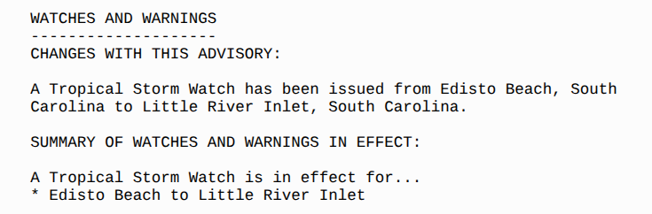
Watches for Edisto Bch to Little River Inlet.

To make it simpler.
Inland from this there will be impacts.
Depends how strong Chantal gets.
Depends how fast Chantal moves.
Slow moving Tropical Storms can bring misery.
So let's hope she doesn't sit and spin too long.
Just saying.
I'll be offline Saturday as I take that day off every week and I'll update Saturday evening. As always follow Mike from Mike's Weather Page. All the people I mention and talk to on X. Mitch from SC and Chick in Fayeteville especially in the area to pay attention inland. Note Myrtle Beach has rain through Tuesday. As always www.spaghettimodels.com has all the info up.

Myrtle Beach NWS info.

That's a whole lotta rain.
Rain profile for the next 7 days.
Note it's possible it is downgraded inland.
Falls apart and yet the rain goes on and on.
Parts of Barry DNA and I believe Flossie...
...embedded into storms over Texas
Made Flash Flooding in Hill County.
23 girls from a Camp are missing.
13 bodies have been found.
It's totally heartbreaking.
Flash Flooding happens.
Err on the side of caution...
..this July 4th!
I'll add in 8 PM info.
Mitch lives in SC and he's on top of this ...trust me!
.gif)
Visible below

Recon found the data.
NHC upgraded.
Cone will be out soon..........
I know it's frustrating for many as it's July 4th Weekend but it's not the first July 4th Weekend to have a tropical visitor to our beautiful beaches. Those of you who went through the heavy rains in Florida will most likely advise people up our way in the Carolinas to pay attention to it. And, say out of the ocean....... my best advice as every strong line of thunderstorms, tropical depression or tropical storm we have people die who thought they were strong Swimmers and they'd be okay. They were not. Stay out of the water!
Earlier today........keep reading if you did not.
Thanks.

60% Anytime.
For all the doubters.
Who insisted it would form in the Gulf.
Crossed over Florida.
Smelled the Atlantic Ocean.
Felt the heat of the water.
And BOOM!

We have Invest 92L
Overnight while you slept.
92L pulled it together!

Watch it spin.

Earthnull shows how closed off it is!

Let's go wide before I say more.
.gif)
This is like being a child and told you can't set up big fireworks, but your parents bought you some sparklers. Obviously, most children would be upset because they want the big fireworks on the 4th of July. But once they start playing with the sparklers and drawing their name in the dark night they are happy and making memories.
Most likely, this will be a short lived system much like the others this year and it will get a bit of hoopla and nothing more. But I would not wager a bet yet that we won't get more. It dumped a ton of rain on Florida and I do mean a ton (collectively) and lightning was intense and now it's all wound up into a little ball over warm waters close in. So it needs to be watched and anyone going to the beach needs to remember it is there and while it may get the name Chantal it can rough up the surf and watch it from the water's edge and stay clear of any lightning.
Too soon to say for sure what it'll do as it's just become an Invest. Now the real investigation goes on behind the scenes. An Air Force Recon is scheduled to go into the system later today and we will know more later today.
I'll update this afternoon.
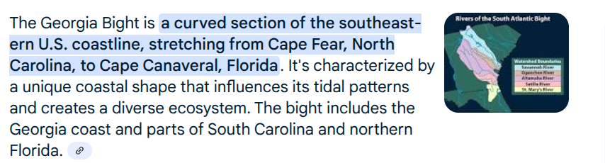
I know I was quiet yesterday. I had some appointments I had to go to and then decided to wait as nothing new was going on and I get tired of saying "something is going to form off the East Coast of Florida" and get up "into the Georgia Bight where the water is hot and it can intensify fast" and make sure you are hurricane ready for what is to come later in the season.
Now there is something to talk on. This is the reason that the whole area from Jax to Wilmington NC is basically the same geographical area. And storms do well here where the water is hot and there is something to the curve of the coastine that helps them spin. This happens off this area and off the Texas Mex coastline. Happens off of China ... lots of places. Geography is always something to take into consideration when watching a developing system close in.
Only one thing concerns me down the road.
Where does the moisture from this go?
What if it makes landfall fast...
...then bounces out into the water.
Many models have played with this solution.

The warmth of Summer.
Has been crazy far up the coast.
A tenacious heat spell held on.
Dug in.
And the water off the coast is hot.
In theory it goes out to sea.
Let's hope so!

More to come...
....will update later
Oldie Summer Tune.
I have a brother who loved old songs since he was a baby bouncing in the playpen. My mother had a record of Oldie Goldie Songs from Texas and I do mean old style Country Western Music when that was a thing. So there he was bouncing along in the play pen to the Yellow Rose of Texas and other old songs. Funny how songs stick in our head and some are connected to summertime.
But we may have Chantal forming. We for sure have a Coastal Low. How far will it go?
Besos BobbiStorm
More to come later today............. music above.


 English (US) ·
  French (CA) ·