
PROTECT YOUR DNA WITH QUANTUM TECHNOLOGY
Orgo-Life the new way to the future Advertising by AdpathwayThe highest volcano in the world is Cerro Ojos del Salado. It is a stratovolcano in South America’s Central Volcanic Zone, reaching an impressive 6893 meters above sea level (or at least above what sea level used to be). It doesn’t look much: the volcano is a mess of overlapping domes with two separate summits, with the border between Chile and Argentina lying along the two summits. It is an old volcano which has existed since the Pleistocene. There is still some activity: the volcano is dormant rather than extinct. The most recent eruption may have been 1300 years ago, and explosion that deposited tephra in the region. But the activity is low enough that each eruption has to create a new magma path. This is one reason for the disheveled appearance: each eruption creates a distinct feature. There are some 20 separate craters. One of these carries the highest crater lake in the world.
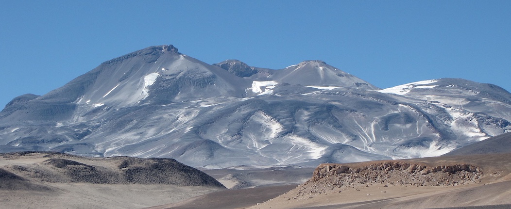
Ojos del Salado. Source: wikipedia
The tallest volcano in the world is Mauna Kea. It stands 4207 meters high. Mauna Loa, the next-door neighbour, reaches 4169 meters. These are puny compared to Salado. But when measuring the height from the surrounding sea floor, the Maunas have it. Mauna Kea becomes 9330 meters tall and Mauna Loa is not bad either, at 9170 meters. Eat dust, Ojos del Salado!
Mauna Loa does have the claim to be being the biggest volcano in the world. It is a shield volcano and therefore very wide. The volume is reported at 75,000 km3, giving a total weight of 200 thousand gigatons. That is 200 times the weight of all the buildings in New York. This beast is badly obese. In fact that is to its own detriment: its weight has depressed the sea floor underneath. It is filling a hole it dug itself.
There is some cheating involved. Mauna Loa looks (reportedly) like an upturned whale, and indeed it has a whale of a time. The bottom 5 kilometers of its edifice, accounting for most of its mass, is below sea level. That means the weight is partly carried by the water – as any slightly overweight person knows, the quickest way to lose weight is by submersion. That has allowed both Manaus to grow a bit more than they would have done on dry land. It also means that with the 20-cm of sea level rise we have had so far, Mauna Loa is able to grow 7 cm or so taller than it did before. By 2100, that could be 20 cm. We are not changing our weather, we make our island volcanoes grow taller.
The question was asked, how high can a volcano get? That is not easy to answer! But we can try.

The world’s tallest volcano: Mauna Kea
Prominence
It makes sense to look beyond the elevation of a volcano to judge its size. Europe’s largest volcano is not Etna. There are several higher volcanoes in the continent, with Elbrus as the number 1 and Kazbek at number 2. Even the Keli volcanic highland stand higher than Etna. But all three (or four, if counting the twin peaks of Mount Elbrus as separate volcanoes) start with an advantage: they have grown on the non-volcanic massif of the Caucasus. It is easy to win a high-jumping competition if your starting elevation counts.

Mount Elbrus, Europe’s highest but not tallest volcano
The prominence of a volcano is measured from its surroundings. That reduces Elbrus to around 2 kilometers. The same is true for Ojos del Salado, which grew on the high plateau of the altiplano. They are also-rans. In contrast, the two Maunas have a prominence that is much more than their elevation. That is also true for that other well-known giant, Olympus Mons on Mars. It has an elevation of 21.9 km (measured above ‘datum’ which is the Martian equivalent to sea level) but a prominence of 26 km because the surrounding land lies several kilometers below datum.
Sometimes it is difficult to know the true prominence. In the case of an island volcano, the depth of the sea floor may be hard to measure. Or the area may be covered with lava flows and it is not clear which volcano they came from, so do they count? Kilauea has grown on the slopes of Mauna Loa, but how deep lies the dividing line? In fact, all Hawaiian volcanoes sit on the slopes of their predecessors, so this problem is not unique to Kilauea. In practice, we take the largest current volcano as being responsible for everything underneath.
Also, note that filling holes does not count. If you built a volcano in a deep crater which it fills up, then only height above the surroundings count. On the other hand, if the volcano is a peak inside a caldera, then it is measured from the bottom of the caldera. It sounds unfair, but that is the rule of the game.
The rise
How does a volcano grow? The obvious answer is that it spits out lava and this creates the mountain. We can currently see this in action with the twin fountains of Hamaumau, which are not only erasing a caldera, but have built a 20-meter tall tephra cone on the caldera wall. But this is not the full story.
In fact, it is more of an afterthought. Since where does that lava come from? Where was it before it erupted? A volcano is just an elevator carrying magma from below to the surface. Basically, since the magma was already there, why would its vertical transport change the total elevation?
Indeed, the initial rise of a volcano precedes any eruption. It rises because magma accumulates below the surface. But doesn’t this just move the problem downstream? Where was the magma before it accumulated there?
The answer is expansion. Rock may seem pretty solid, but it can change its volume and when it does, this creates an irresistible force. Its volume increases when it becomes hotter – very slightly, but the temperature change can be large. If there is a mantle plume below the surface, the heat this carries up makes the rocks underneath warmer and larger – and the ground inflates.
More significant expansion occurs when the rock melts as well. Now the rick may expand by 10%, and this has immediate impact. So it is the melt that forms the magma that is the main first cause of the volcanic rise. The cause is the fact that rocks underneath are becoming less dense. And like a cork in water, this pushes the land up.
The basic model for the uplift was devised by a Japanese seismologist called Mogi, and with all the creativity of scientific language, is called the Mogi model. It assumes a spherical magma chamber, with a certain diameter and pressure, located at a depth below the surface which is much larger than its diameter. This round blob pushes up the surface over an area beyond its own diameter.

The Mogi source model for uplift from a magma chamber
The deep magma at the bottom of the crust is mainly located in sills, and this spreads the rise over an even larger area. The surface rises, but it is diluted because ot happens over such a large area. Magma formation is also slow, and this rise may occur over near-geological time scales. We see the bulge, but don’t normally see the rise. There are exceptions: Uturuncu, another twin-peaked volcano (why do volcanoes split so often? And should we call it multiplication or divorce?) in the Andes is rising by a centimeter per year and has done so over decades.
These bulges can be enormous. Before a flood basalt, massive amounts of magma accumulate at depth. These can push up the land by a kilometer or more, over a thousand kilometers across. If this happens below sea, the sea level rise across the world can be ten meters or more.
Location, location, location
The three most important aspects to consider when buying property are listed above. Everything else is secondary, or even quadronary. That is true when siting volcanoes as well. Why do the Caucasian volcanoes start out so high? What pushed up Ojos del Salado?
The answer is the same as before, just without involving heat or melt, meaning it is non-volcanic. These volcanoes are built on mountains. So what makes non-volcanic mountains grow?
There are two aspects. First, they are built on continental crust. Oceanic crust is made out of mantle material: it is dense stuff. Continents are mainly made from silicates, such as granite. This material is less dense, and this has made the continents rise. This is why seafloor is flooded and continents are not (with exceptions, of course). In a human analogy, mantle material has more muscle (higher density) and continental crust more fat (lower density).
The amount of the rise depends on the thickness of the crust. In places such as the Afar Triangle, the crust has thinned and this made the land sink. This suggests that non-volcanic mountains form where the crust is very thick. And this is correct. A continental collision forms a crumple zone where the two crusts are squeezed together. This makes the crust twice as thick, and therefore it rises twice as far. Roughly speaking.

The Grand Teton mountains in Wyoming, possibly the visually most impressive mountain range I have seen
This tells you something else: composition matters. Shield volcanoes are mantle-like in their composition, therefore have higher density and tend to sit a bit deeper. Stratovolcanoes are made out of more silica-rich, lower-density magma and sit a bit higher. That in itself may make a 10% difference in the prominence.
From bulge to peak
Clearly, there is more about the rise of a volcano than a large inflated bulge. They are prominent peaks above the surroundings. How does that happen?
It comes from another aspect of the Mogi model. A deep magma chamber pushes up the land by a small amount over a large area. A shallow one produces inflation that is much more focussed: a larger amount over a smaller area. The change from bulge to peak begins with one from a wide bulge to a narrow one, caused by the upward migration of the magma.
It is this aspect that makes tilt measurements difficult to interpret. It may be caused by deep magma, in which case a small tilt can be due to a large magma volume. Or it can be from a shallow chamber, giving a much larger tilt for the same volume. It also depends on where the tilt is measured. Put the instrument on top of the intrusion, and it will show no tilt at all. Put it far away and the tilt may go down as the magma rises. To make sense of tilt, you need to know where the magma is located. Mogi tells us so.
Finally, magma makes it to the surface. From the previous discussion, there will probably already a bulge in the landscape. But as the fresh lava comes out, it quickly builds a better peak, with a strong prominence. The conical shape of volcanoes comes from the surface lava flows. The higher the viscosity, the less the lava flows and the steeper the cone becomes. Shield volcanoes have low viscosity lava which flow easily: they build a shallow edifice. The bottom line is that a shield volcano needs much more magma to reach the same prominence as a stratovolcano. Luckily, because shield volcanoes get their magma from deep heat, they normally have a much more voluminous magma source. Low production rates tend to produce shields which have so little prominence that they can be hard to recognize. There are some examples on the Reykjanes peninsula, but they are not the peaks that draw the tourist’ eye.
Down again
So this is how volcanoes grow. But clearly, there are limits to the growth, as pointed out by the Club of Rome many decades ago, or by Thomas Malthus long before that. What are the limits for volcanoes? The fact that Mauna Kea, Mauna Loa and Everest are rather similar suggests there is a limit. In fact, Olympus Mons is not dissimilar: Mars’ gravity is about 38% of that of Earth, and 38% of 26 km (the prominence of Olympus Mons) is 9.8 km which is only a little higher than the prominence of Mauna Kea. Is this a natural limit?
The problem with volcanoes is that they may grow very fast. They can end up becoming unstable. A stability analysis is insufficient: they may not be stable. So a better question is how high a stable volcano can be.
The same question can be asked about mountains in general. Why are some mountains higher than others? For instance, the Japanese mountains pushed up by the subduction zone are on average only around 1km high, while on the other side of the Pacific, the average height is 5 km. These are notable differences.
One suggestion is that the height of mountains is determined by the balance between the tectonic growth rate (how fast mountains are pushed up) and the erosion rate (how fast they are taken down). As mountains become higher, glaciers form on their slopes and they greatly enhance erosion rates.
The other suggestion is that it is limited by a spreading force. The weight of the mountain pushes down on the subducting plate. This is balanced by friction at this interface and by viscosity. If the weight exceeds what these two forces can withstand, then the subducting plate will be forced to move faster and the mountain will sink until the forces are in balance again.
The second suggestion seems to fit the height of the various mountain chains well. This is shown in the figure where the average mountain height is compared to what the subduction zone can support.
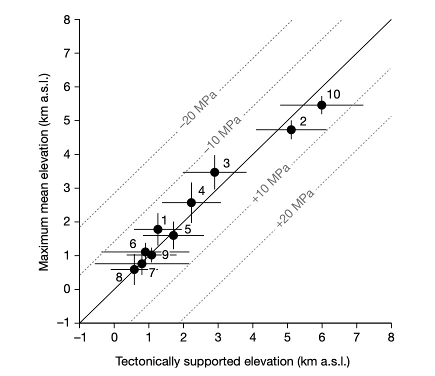
Source: Armin Dielforder, Ralf Hetzel & Onno Oncken, Nature, volume 582, pages 225–229 (2020)
This suggests that tectonics limits the height of mountains. Specifically, this is caused by friction and viscosity. But note that it does not limit the height of individual mountains in the chains. These are small enough that their weight gets distributed over a larger area of the deep subduction zone. As long as they are separate peaks, they can survive.
Is there any other limit? There is another important one, and it is caused by another transition zone. Underneath the crust lies the asthenosphere, a region where the mantle rock are hot and weak, and are even a little molten. Put this under pressure and it will flow sideways. It is a slow process because the viscosity is still very high. This is what caused the ground to sink underneath the weight of the glaciers of the ice age, and the rebound afterwards. In many places this rebound is still un-going. It limits the height of mountains but acts very slowly. If the mountain grows quickly, it has no problems. But over a millennium and longer, the asthenosphere will give away and the mountain will sink. In fact, even New York is isostatically sinking.
This is a much worse problem for volcanoes than it is for ordinary mountains. Volcanoes require heat, and this heat increases the melt fraction and weakens even the crust. So the response is much faster than it was during the ice age. This effect is at play at Mauna Loa. Away from most lava flows, the subsidence is measured along the coast: at Hilo it amounts to around 5 millimeters per year. Mauna Loa itself is compensating for this from intrusion of new magma and of course regular eruptions, but overall Mauna Loa appears not to be growing anymore, as shown by the subsidence on its distant flanks. Other volcanoes also show this effect, battling subsidence with growth. Hekla is an example of a young volcano where the crust has not yet adjusted to its weight and is giving way, but the eruption rate more than compensates.
Once a mountain stops growing, erosion kicks in. Volcanoes often suffer flank collapses. These remove much of the weight, and allow the remainder to survive. Also, when volcanoes go extinct, the heat below is gone and the crust re-strengthens.
There is one more limit to consider. A cold, stiff crust can carry more weight, but is also subject to faults. These faults give way long before the crust itself does. All mountains have this problem, and these faults are often relatively shallow, so sensitive to local, small-scale effects. It may be that these faults eventually limit how large a single peak in the mountain range can be.
Bottom line
So what sets the limit to the size of a volcano? All these effects come into play. For large volcanoes, the limit they run into is the growth rate versus the isostatic subsidence. As a volcano get larger, and especially for shield volcanoes with their large bulk, the growth rate declines as more and more volume is needed for adding each centimeter of height. Eventually, this runs into the buffers. Finally, we have seen that more and more of the eruptions occur on the rifts – and these don’t add height to the summit. Rift eruptions become more likely when the volcano grows taller.
Stratovolcanoes may seem to be a better bet, because they have less bulk (steeper flanks) and also weight a bit less for their volume. Also, they have less heat underneath so have less problem with the asthenosphere giving way. But in reality, stratovolcanoes do not have prominences near those of the Maunas, so clearly they have a problem. Two problems, in fact.
Their first problem is that the magma supply is typically low, and therefore the growth rate is small. This makes erosion the limiting factor. There are exceptions, for example Bagana may be the fastest growing (and youngest) volcano on Earth. But such rapid growth tends to be limited to the early phase, before the initial magma supply is exhausted. The second problem is that when these volcanoes age, they tend to blow their tops. Mount St Helens is a good example. These explosions set their own limits to the growth.

Bagana, the world’s fastest growing volcano. Source: Oregon State University
So why did Cerro Ojos del Salado grow so large and survive for so long? It had two advantages: a very long-lived (albeit low level) magma supply from the subduction zone, and an extremely low erosion rate. The Central Volcanic Zone of the Andes is located in the driest region, with little rain and few or no glaciers. Erosion is mainly from wind and rock can last a long time. As it has done.
How can a volcano reach its limits? The best recommendation is to go for location, location, location. Where is erosion at its least? It is under water, where there is no rain or wind, and wave erosion is limited to about 50 meters below sea level. Submarine edifices can live as long as the ocean flor they grow on. But for reaching the heights of the Maunas, they have to put their heads above water, with all the problems that entails.
There is another way. Go for a place with less gravity, a stronger crust and no erosion. Olympus Mons got it right: go for Mars.
Albert, June 2025
For Olympus Mons, we refer to Henrik’s story: Mars 2067, the Olympus Mons Expedition


 English (US) ·
  French (CA) ·