
PROTECT YOUR DNA WITH QUANTUM TECHNOLOGY
Orgo-Life the new way to the future Advertising by Adpathway
Nothing for 2 days, nothing for 7 days.
Lots of talk on a new African Wave.
Time will tell ....
...so let's look at the Mimic.
Doing it in parts today.

Mostly looking to N of here..
..but you get the idea.

Below a good map with Matthew & Sandy.

Link below to the old Bloomberg Article..
...this map is shown in and seen online often.
Things that concern me. The Western side of MIMIC shows a moist Gulf and Caribbean along with the Coastal area from Mid Atlantic down to Florida that's being soaked with a late "rainy season" from stalled out frontal boundaries that drape themselves South of Ocala. IF a named storm was to be placed into this current set up it would have a route across Florida or up out of the Carib across Cuba/Florida Straits perhaps or if said storm formed down in the Caribbean.... down where Matthew or Sandy formed it could pull North through the Windward Passage and depending on the placement of a front it could go out to sea or curl back in as the MIMIC does here showing a possible landfall from NC/VA North up the coastline towards NYC or NE.
Yes this is today, but I have saved multiple daily shots for days and days and the Mimic always looks the same. This area is ripe with moisture and the only thing holding it back is ribbons of wind shear are draped like strands of decorations you'd put up around the house down the road as one holiday flows into the other. Basically more like blobs of wind shear depending on the particular day, sometimes thin sometimes amorphous blobs denoting an unfavorable environment. One reason are 2025 Hurricane Season is on a temporary hold.

Wind Shear is everyone's friend in West FL
Where they really, really want a rest.
From I storms or even a M storm.

Eastern side of the MIMIC.
Horizontal, flat flow across ITCZ
From South America to Africa.
A thin horizontal E bound flow at the top.
We now have a SE to NW flow mixing in.
And a wave leaving Africa....
...that many models are latching on to.
The differences are stark and real.
Moist with shear, Dry unfriendly.

There's the whole Mimic above.

A good wave is hard to find in 2025.
If you read the statement from CSU...
...in the previous blog post.
He did mention this in his own words.
Link to Dr. Phil Klotzbach statement below.
Generally the waves become strung out...
..stretched out as 91L was more a wave complex.
Complex means more than one area...
... multiple centers and rain not aligned in any way.
New wave is big.
Below are the ensemble models from this morning.
Mike posted them and I thought it would be good to use it.
He's on live at 9:19 AM most days.
Facebook, YouTube lots of places.
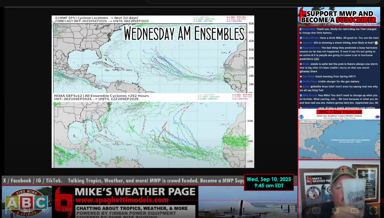
You can see the wave making it far into the Atlantic.
Also one model shows CAG possibilities.
CAG is usually October, but sometimes in Sept.
Every year is different.
I think Andy Hazelton says it best here.

"We'll see if the signal holds...
as it comes off or fades"
Yup.
So will NHC put up a Yellow Circle?
Even a 10% Yellow Circle?
Or will they wait til it shows some spin?
Everyone a bit burned by 91L
I get it but at some point......
...models are onto something.
Or they are junk models?
Will wait. Will watch.
I'm watching both sides of the Basin.
Western Carib/GOM
Eastern MDR/E ATL.
I looked through some statistics.
Hurricane History.
Florence was one of the latest landfalls.
From a Cape Verde Wave.
September 14th.
Always other examples.
Many are kind Fish Storms.
October we tend to look SW to the CAG.
Close in development at tail end of fronts.
What are you watching ?
Leaves turning?
Light rain falling in Carolinas?
Maple Pecan coffee brewing?
Ginger Pumpkin Cookies?
Candy Corn?

Earlier I listened to Mike's Daily Brew talk this morning...
... while I sipped my La Colombe Draft Latte.
Mike has a huge site and yet many people only look at the Main Page. Someone asked him a question this morning and he knew exactly where the link was that explained the TUTT to a person in chat and asked him how it works. If you want to learn more on how the tropics work it's a good idea to wander off the Main Page at Mike's Weather Page than just looking at the main graphic of Spaghetti Models when there's an Invest. Today no Pasta is on the menu but there is some thought it may be coming back soon!
Other than enjoying listening to Mike talk in the morning, old habit, I like to see what people ask and are curious on as it gives me a reminder to mention things when I am writing vs just typing or going off on a rant as I do something, especially when it's "slow" vs busy and there's plenty to say. Also, he makes us laugh and laughter is a good thing in a world with a never ending flow of sad news stories and destructive weather hitting somewhere. Mike knows how to enjoy life. I love that about him.

Old friend. Good friend.
LOL he says Dunedin properly!
He's from the Tampa area.
I have deep Tampa roots in my family.
There's a time for deep academics.
There's a time to try and explain with humor.
Right now there is no tropical threat.
There is no Cone in the Atlantic.
No yellow circle, though one may show up soon.
As for the African Wave.......
... seems to be the only game in town today.
Sweet Autumn Dreams
BobbiStorm
@bobbistorm on X
X mostly weather ...
Volcano is a darn good CD
Lots of good songs.
links below the songs...
Thank you for following along my weather diary.
While I share thoughts with y'all
And while I process my thoughts often in real time.
Then I can move on with chores for the day.
And I can look back at my thoughts on
Sandy and Matthew in the blog when I need to!
https://www.bloomberg.com/news/articles/2017-10-31/how-does-hurricane-sandy-compare-to-harvey-irma-and-maria good article from 2017 especially as it relates to October Hurricanes that pull North from the Caribbean to late season landfalls.
CSU report put up yesterday by Dr. Phil Klotzbach in my previous blog you can read as well.


 English (US) ·
  French (CA) ·