
 5 months ago
130
5 months ago
130
PROTECT YOUR DNA WITH QUANTUM TECHNOLOGY
Orgo-Life the new way to the future Advertising by AdpathwayDisclaimer: This site is not affiliated with the National Hurricane Center, Hurricane Hunters, Storm Prediction Center, or National Weather Service. ALL forecasts herein are the result of my analysis, (to which you will see me at times, insert excerpts from various agencies due to the nature of the importance of the information) and I am solely responsible for the content. As ALWAYS, follow the National Hurricane Center, National Weather Service, and your local Emergency Management officials for emergency decisions. In addition, this is strictly a FORECAST OFFICE. I CANNOT make decisions regarding travel plans, etc. My purpose, is to provide you the information, based solely on information I analyze, and the accuracy of the information at hand of the time of analysis, so you may make informed decisions.
(T. F. “Storm” Walsh)
For those who have donated to my site, your help has been greatly appreciated. If you are not aware, donations to my site help pay for subscriptions to sites I use as well as software updates, which provide all the models and information used in my forecasts. To donate, please click the DONATE button to the right side of the page, or on the graphic of the dog. Any help you provide is immensely appreciated!
DONATIONS ACCEPTED AND APPRECIATED


I will reiterate, my forecasts are based on the available information at the time of analysis, and are only as accurate as the information analyzed and the solutions provided.
Good day everyone!
Just to reiterate, though some of my forecasts may not directly apply to you or your particular weather group, I have no idea where your families or friends reside, and this is the reason you may receive the forecasts.
The Storm Prediction Center (SPC) has issued a MARGINAL risk for severe thunderstorms in the current DAY 3 Outlook: OVER PORTIONS OF THE CENTRAL AND EASTERN GULF COAST…
…SPC SUMMARY…
Isolated strong to severe storms are possible over portions of the central and eastern Gulf Coast Sunday.
SPC DAY 3 SEVERE THUNDERSTORM OUTLOOK (LINKED FOR OUTLOOK TEXT)

The following is the day 3 severe probability from the CSU – MLP severe weather forecast map vs the SPC forecast, and the NSSL ML day 3 severe probability, with both indicating a possible upgrade to a slight risk outline:
CSU – MLP DAY 3 FORECAST (CLICK FOR LARGER IMAGE)
NSSL DAY 3 SEVERE FORECAST PROBABILITY (LINKED)

DAY 3 PROBABILITY CONVERSION TABLE
SPC DISCUSSION EXCERPT:
…Gulf Coast…
As the surface low moves onshore and deepens ahead of the advancing shortwave early Sunday, inland moisture advection (60s F surface dewpoints) is expected to increase over southeastern LA into southern MS/AL and the western FL Panhandle in the wake of a surface warm front lifting northward. Ongoing elevated convection near the advancing cold front will likely encounter a warming/moistening boundary layer sufficient for some intensification through the day across south-central AL into the FL panhandle and southwestern GA.
Increasing southwesterly flow aloft (EBWD of 50-60 kt) will be favorable for some storm organization amidst weak buoyancy (MLCAPE ~ 500 J/kg). A broken band of storms along the cold front may pose a risk for isolated damaging gusts and brief tornado where the boundary layer can destabilize sufficiently inland south of the prominent cold air intrusion/damming and ongoing winter weather. The cold front will then continue offshore overnight with the severe risk diminishing as a much colder air mass envelops the eastern CONUS.
EBWD: (Effective Bulk Wind Difference, a meteorology parameter measuring the magnitude of vertical wind shear between the “effective inflow layer” and a higher point in the atmosphere. Used primarily to forecast supercell thunderstorms and tornadoes, it represents the average wind shear through the inflow layer up to 50-60% of the thunderstorm’s depth)
Based on analysis of some severe forecast indices and parameters this morning, the atmosphere is currently forecast to be marginally unstable. The current preliminary forecast indices indicate weak mid level lapse rates at around 6.0 – 6.5 C/km. Forecast lifted indices indicate marginal instability, ranging from 0 to -2. SBCAPE is currently forecast between 50 – 750 J/kg-1, and MLCAPE 250 – 500 J/kg-1. All severe hazards appear to be possible for Sunday. Based on preliminary EBWD, SRH of 200 – 600 m2/s2, and 0 – 6 km shear of 50 – 70 kts, the main threat at the moment appears to be damaging winds / gusts and isolated tornado activity. IF any tornado and hail activity do occur, I currently expect it to be weak. Based on preliminary data, strongest activity appears to initiate very late morning to around 12 Noon CST.
NADOCAST forecast maps will not be available as they are only issued for the Day 1 severe weather events. I will not be available on Sunday for the Day 1 outlook, so I intend to update tomorrow with the preliminary forecast data. The following link is for access to NADOCAST maps:
NADOCAST SITE LINK:
http://data.nadocast.com/
(CLICK ON THE CURRENT MONTH ON THE LEFT)
The following links will connect you to the Excessive Rainfall probabilities and River Flood Outlook:
EXCESSIVE RAINFALL
https://www.wpc.ncep.noaa.gov/qpf/excessive_rainfall_outlook_ero.php
SIGNIFICANT RIVER FLOOD OUTLOOK
https://www.wpc.ncep.noaa.gov/nationalfloodoutlook/index.html
The following NWS Watch / Warning map will provide local NWS information for your area. Click the image, then once it refreshes, click on your area of interest to view forecasts, any special weather statements, hazards or advisories for your area.
NWS WATCH / WARNING DISPLAY (LINKED…CLICK MAP, THEN YOUR AREA)
NWS DOPPLER RADAR LOOP (LINKED, CLICK RADAR MAP)
RAP RADAR (CLICK IMAGE THEN GO TO LOOP DURATION AND PICK LENGTH OF LOOP, THEN CLICK RADAR SITE)
WUNDERGROUND RADAR SUMMARY MAP (CLICK FOR UPDATES)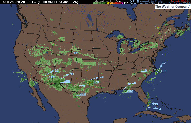
PRECIPITATION TYPE (CLICK TO ACCESS ANIMATION FEATURE)
CARIBBEAN RADAR (CLICK IMAGE TO ACCESS ANIMATION)
You may direct any questions by contacting me personally, ANYTIME, at: [email protected]
Have a blessed day!
T. F. “STORM” WALSH III
GMCS, USCG (ret)
METEOROLOGIST / HURRICANE SPECIALIST /SEVERE WEATHER SPECIALIST


 English (US) ·
  French (CA) ·