
PROTECT YOUR DNA WITH QUANTUM TECHNOLOGY
Orgo-Life the new way to the future Advertising by AdpathwayBy John Cavitt
John Cavitt is a Distinguished Professor of Zoology at Weber State University in Ogden, Utah. For over two decades, his research has focused on the ecology and conservation of Great Salt Lake birds. He has tracked shorebirds from Utah to the coast of Mexico, banded birds in Siberia, and spent more field seasons than he can count watching a lake he loves grow smaller. He writes and speaks regularly on Great Salt Lake conservation and can be found on Instagram @birdecologyguy and LinkedIn at linkedin.com/in/johnfcavitt
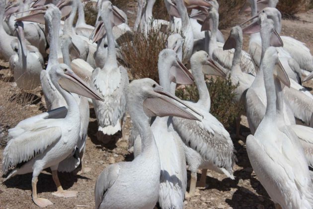
There are moments on the water in the American West that stop you cold regardless of what else you came to do. I have had that experience more than once, watching American White Pelicans (Pelecanus erythrorhynchos) lift off the surface of freshwater impoundments surrounding Great Salt Lake (Figure 1).
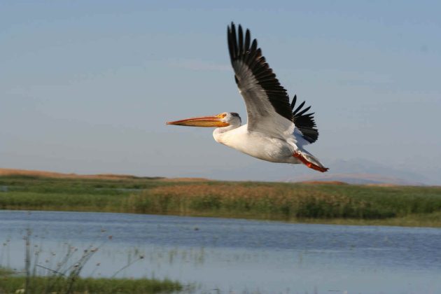
The birds run hard before becoming airborne, each one laboring briefly before those broad wings take hold. Once up, they circle to find lift, and when they locate a thermal, the transformation is immediate. The chaos of the takeoff settles into a long column of white birds tilting in unison, rising until the flock becomes a slow spiral. After more than two decades of fieldwork on this lake, that sight has not lost its hold on me.
It is a striking display, but it masks a deeper reality. Despite this species’ massive size, these birds are vulnerable. Gunnison Island (Figure 2), a barren ridge of desert rock in the northern arm of Great Salt Lake, …
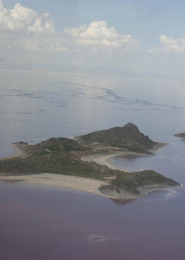
… hosts what was for much of the past three decades the single largest American White Pelican breeding colony in the interior West (Figure 3).
I know this firsthand from the years spent compiling the Atlas of Breeding Colonial Waterbirds in the Interior Western United States[1], a systematic survey of colonial waterbird colonies across eight states. In that work, we documented 41,709 breeding American White Pelicans at 24 colonies. Gunnison Island, with more than 10,000 birds in 2009, dwarfed every other colony.
For most of its recorded history, it has stood in a category of its own. The written record reaches back to May 1850, when Captain Howard Stansbury of the U.S. Army Corps of Engineers conducted the first scientific survey of Great Salt Lake. During this survey, he explored Gunnison Island, writing that the ground was literally “covered in eggs and young birds”. He described thousands of adults forming massive, unbroken white blankets across the rocky ridges. Stansbury’s account shows that this island served as a pelican colony for at least 175 years[2]. Pelicans have returned to it generation after generation.
That colony is now in serious trouble. The reasons for its decline tell us a great deal about how saline ecosystems collapse and reveal some hard truths about society.
The Crossing: Heavy Water and Vanishing Geography
I visited Gunnison Island on July 23, 2014, as part of a pelican banding effort. We loaded onto two research boats that morning, unsure if the weather would cooperate. Winds had kicked up across the lake, and the crossing was uncertain. Boating on Great Salt Lake reveals a strange hydrology. The brine is heavy and dense, behaving by its own peculiar physics. Because the basin is so shallow, a stiff wind causes waves to stack into rapid, steep walls with almost no interval between them. Rather than riding over the chop, the boat’s hull plowed through dense barriers of brine, each wave slamming into the bow and forcing us to a crawl.
On the way out, we passed the remnants of the old Lucin Cutoff trestle, the twelve-mile wooden railroad bridge completed in 1904 to shortcut the transcontinental route directly across the lake. Most of what remains today are scattered pilings and beams, encrusted so heavily in salt that they have effectively become concrete. (Figure 4, 4b) I couldn’t resist touching it. The surface was hard and completely mineralized, a bizarre artifact suspended somewhere between history and geology.
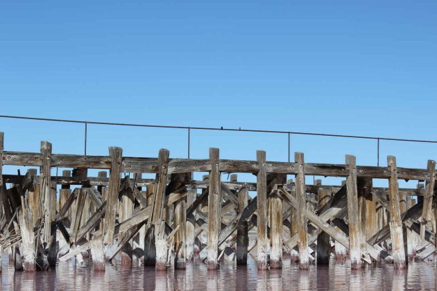
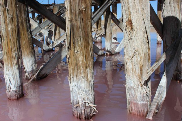
As I reflect on that day and these pelicans, that petrified trestle is a monument to a time when humans thought they could permanently conquer the lake’s geography, but now frozen in place by an ecosystem that reclaims everything eventually. The loss of the lake’s water is doing the exact opposite to the pelicans. Rather than preserving the island’s geography, we are erasing it, converting a water-locked sanctuary into a terrestrial corridor for predators.
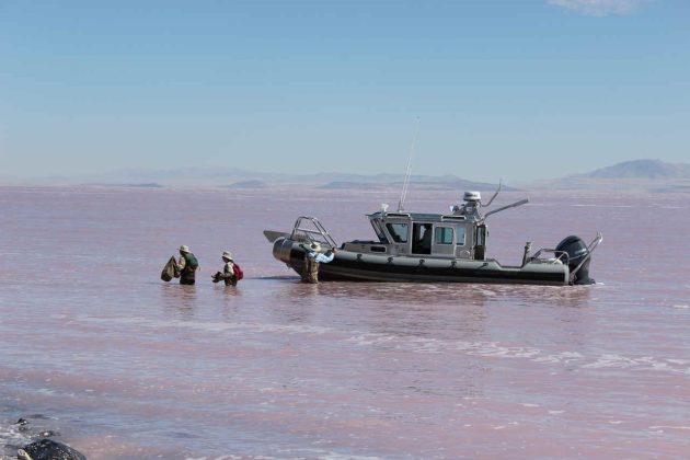
We could not bring the boats close to the island without risking grounding them, so we hopped out and waded the last stretch through hip-deep salt water, holding our gear above our heads (Figure 5).
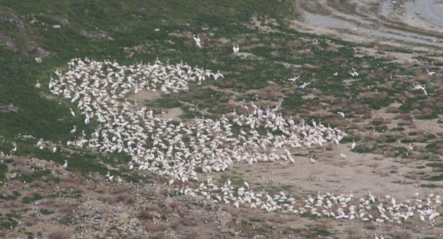
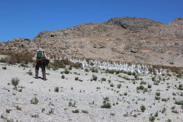
Once ashore, we hiked to one of the island’s high points to locate the largest crèche of pre-fledgling pelicans we could find (Figure 6).
Into the Crèche
Young American White Pelicans present a deceptive picture. By mid-July, they are nearly adult-sized but still entirely dependent on their parents for food and completely incapable of flight. They congregate in crèches, dense aggregations of young birds waiting for their parents to return with a meal. Because they cannot fly, they are relatively easy to capture and band.
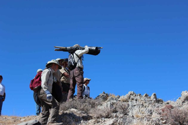
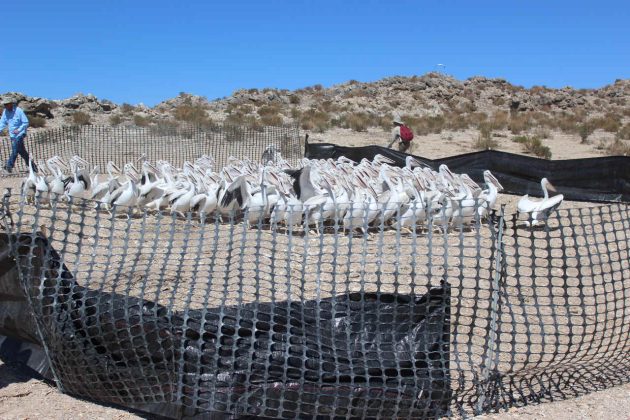
What followed was as close to a military field operation as I have experienced in research. A team of drivers spread out wide around the back of the crèche while the rest of us quietly moved downslope to a narrow bottleneck in the terrain (Figure 7). We erected a large snow fence in a U-shape, its open mouth facing the approaching birds, and stationed ourselves at the ends, staying low and still.
As we waited, I could feel the air changing. A heavy reek of concentrated uric acid and fish oil swept down the draw well before the first white bodies broke over the ridge. Hundreds of young pelicans waddled at maximum speed down the slope and funneled straight into the fence (Figure 8).
Once they crossed the threshold, we pulled the ends together, securing roughly 250 to 300 birds in our makeshift corral (Figure 9).
The processing line ran with practiced efficiency (Figure 10).
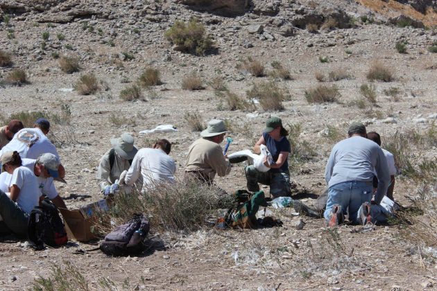
Crew members inside the corral kept birds from crowding the mesh while handlers passed individual pelicans to runners. Safely handling an eight-kilogram pelican requires a specific sequence. First, you take control of the massive bill with one hand, then fold the thick beating wings against its body and tuck the bird under your other arm. All the while, keeping the bill slightly open so the bird can cool itself through the rapid movement of its throat muscles. This gular fluttering is its primary defense against overheating on a baking desert rock.
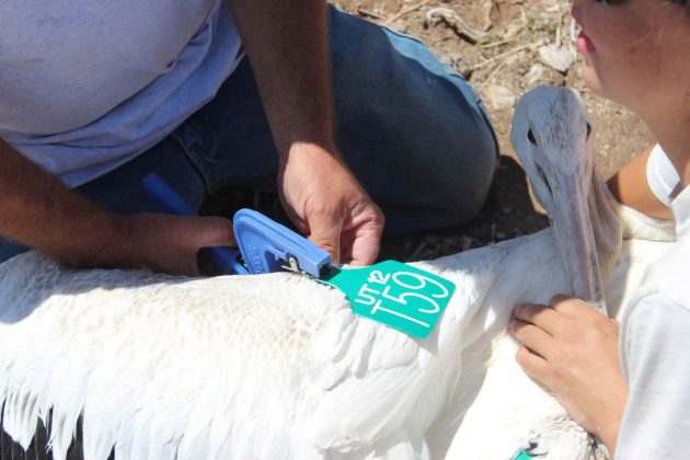
Runners moved each bird from station to station: a USGS metal band applied to one leg, standard morphometric measurements taken, body weight recorded, and finally, large green patagial wing tags bearing the letters “UT” followed by a unique code were secured (Figure 11).
By the end of the day, we had banded 275 young pelicans, a single-day record for the island and part of a season total of 540 tagged birds.
From Utah to Baja: A Continental Connection
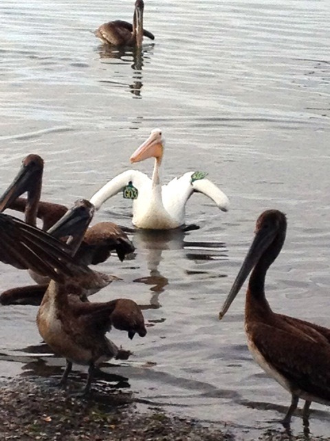
Those green wing tags unlock our understanding of how this population moves across the hemisphere. A resighting reported to me by a former student illustrates the point. On February 24, 2014, Jonathon Vargas spotted and photographed an American White Pelican at Puerto Adolfo López Mateos, Baja California Sur, Mexico. The tag read UT-12, G03. That bird had been banded on Gunnison Island’s Seagull Bay on June 20, 2012, and was wintering on the Pacific coast, roughly 1,650 miles from where it hatched (Figure 12).
Jonathon worked with me for two breeding seasons at Great Salt Lake. I can tell you it brings real satisfaction to see a student trained in Utah cross paths with a bird from the lake while working in his home country. The encounter underscores the deep, biological connection across the Pacific Flyway. It connects a remote salt island in the West to a coastal lagoon in Mexico.
Biologists in Mexico who count wintering pelicans at Puerto Adolfo López Mateos are, in a very direct sense, monitoring the downstream consequences of upstream water management in Utah. Jonathon’s resighting is a data point, but it carries a larger lesson: what happens to this lake reaches all the way to a coastal lagoon in Mexico.
Why Gunnison Worked
American White Pelicans did not end up on Gunnison Island by accident. Colonial waterbirds concentrate at specific sites for reasons rooted in their evolutionary history. Over generations, the birds that clustered on predator-free islands raised more offspring than those that did not, gradually binding entire regional populations to a handful of sanctuaries. When surrounding water levels fall and those sanctuaries cease to be islands, that evolutionary preference becomes a liability.
Ground-nesting waterbirds are extremely vulnerable to mammalian predation. A single pair of coyotes working an accessible colony can destroy hundreds of nests within days. Genuinely safe locations for this species are rare, so the regional population concentrates at just a few sites.
Yet, that concentration carries a cost. When a major colony site fails, it can significantly impact a large proportion of the species population. A predation event or large-scale nest abandonment can remove an entire season’s productivity from tens of thousands of birds in a matter of weeks, with no compensating reproduction anywhere else on the landscape.
Gunnison Island has functioned as a colony for one reason: isolation. The surrounding brine keeps terrestrial predators at a distance that ground-nesting birds cannot otherwise achieve. Pelicans tolerate the heat, the corrosive water, and a long daily commute to freshwater foraging sites precisely because that moat has historically kept their chicks safe. Remove it, and the entire reason for using the site collapses.
Timeline of a Colony Collapse
The historical record documents the loss of that isolation. When the Atlas survey was conducted in 2009 and 2010, Gunnison Island held over 10,000 breeding adults. The colony peaked at 20,270 adults in 1992 and remained large through the early 2000s. By the time of my 2014 banding visit, the count had dropped to 9,428, less than half the 1992 peak. By 2017, the annual count had fallen to 8,342.
That same year, Utah Division of Wildlife Resources biologists installed trail cameras on Gunnison because a land bridge had formed on the southern portions of the island, and there was concern that coyotes may locate the colony. The trail cameras provided exactly that evidence. The predator pressure that open water once made irrelevant was a documented threat.
The decline accelerated from there. By 2019, an aerial survey found only 6,928, and the southern portions of the island, where land bridges had first exposed the lakebed, showed no nesting activity at all. The pelicans were retreating toward whatever corners of the island still retained a functional water barrier. By 2022, the colony had declined to roughly 5,800 adults, the lowest count since the 1970s and almost half the size reported in the Atlas.
Then came 2023. Utah recorded a historic winter snowpack, and by any logic, this should have meant a rising lake and a reprieve for the colony. Instead, the colony collapsed entirely. Roughly 3,000 nests were initiated in May. Fewer than 1,000 young remained by June. By July, only 40 to 50 chicks survived on the island before finally all adults abandoned the site. It is suspected that no young fledged successfully that year, an entire colony had collapsed.
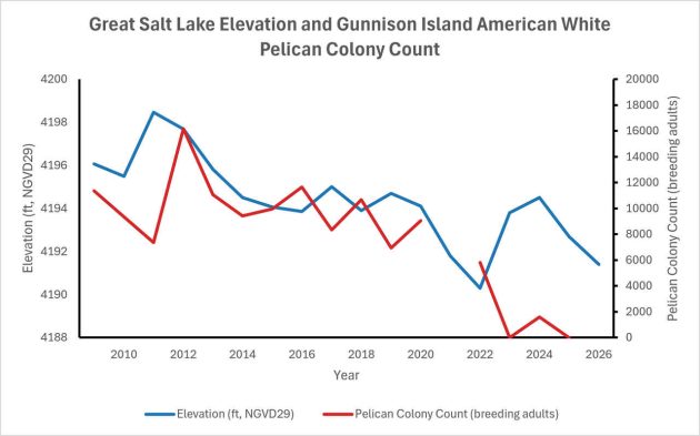
A single exceptional snowpack cannot overcome a multi-decade cumulative water deficit. Flows from Utah’s mountains pass through an ever-increasing agricultural and municipal system that consumes the substantial majority before water reaches the basin. What finally arrives is insufficient to raise the elevation of a large, shallow terminal lake against summer evaporation. The record snowpack helped, but it could not rebuild an island[3](Figure 13).
Figure 13. July 1 elevation of the Great Salt Lake measured in the south arm at the GSL Boat Harbor plotted with the American White Pelican breeding-adult colony count at Gunnison Island, 2009–2026. A land bridge connecting Gunnison Island to the mainland was noted in 2017. A lagged linear regression in which lake elevation in year Y predicted colony size in year Y+1 indicated a strong positive relationship (n = 15, r = 0.71, R² = 0.51, p = 0.003); each one-foot decline in lake elevation is associated with a loss of approximately 1,576 breeding adults at Gunnison Island the following year.
Trying to Find a Future
The pelicans have not given up. They returned to nest in 2024 and also appeared on Hat Island for the first time since 1943. That redistribution is significant; the birds are spreading across multiple sites because Gunnison is no longer reliable. Hat Island is much smaller than Gunnison and is also connected to the mainland via a land bridge.
Reports from 2025 indicated nesting at Gunnison remained precarious, with some birds apparently attempting to nest on the earthen railroad causeway that replaced the wooden trestle in the 1950’s. As of June 2026, state biologists have confirmed nesting on Gunnison, though no formal count has been released.
As of this writing, Great Salt Lake currently sits near 4,191 feet, close to its modern historic low. The land bridges on Gunnison and Hat Islands remain open. The colony that once anchored pelican breeding productivity across the interior West is operating under conditions that would have been unrecognizable to the birds that nested there in 1992.
Restoring that productivity requires putting water back into the lake, enough to re-establish the isolation that makes Gunnison viable. Organizations like the National Audubon Society and The Nature Conservancy are pursuing water transactions that could meaningfully increase inflows, and the Great Salt Lake Commissioner’s office and state water managers are navigating the policy decisions that will determine whether the lake stabilizes or continues its decline.
The pelican Jonathon photographed in Baja California in February 2014 would be roughly fourteen years old now. American White Pelicans can live twenty-five years or more. That bird may still be making the journey north each spring, looking for an island surrounded by water. But the geography it relies upon is fracturing.
Part of what that fracturing reveals about us is a quiet corruption of memory. The biologists who documented 8,342 adults in 2017 and recognized a crisis in progress were right to be alarmed. But someone who had stood on that same shoreline in 1992 and watched more than 20,000 pelicans work a summer thermal would have recognized those 8,342 birds as a catastrophe already decades old. We lose our reference points gradually.
Each generation of researchers, water managers, and citizens inherits a smaller lake as their baseline for what is normal, calibrates its sense of urgency to that diminished standard, and passes an even smaller lake to the next. As the baseline slips, the point at which anyone thinks to sound the alarm slips with it.
What makes this even harder still is the second lesson the trail cameras taught. The biologists did their job. For more than a decade, the pelicans sent clear, repeated warnings that the lake’s health was declining, acting as the early alarm system for a dying lake. But we are now seeing evidence begin to accumulate far beyond a single species on a remote rock. The symptoms of ecological collapse are rippling across the entire basin.
State scientists documented the land bridge, the coyote evidence, and the breached geographic sanctuary, putting the systemic failure of this saline ecosystem firmly on the record. The research was published, and the press covered it — television, newspapers, and radio all carried the falling counts and the warnings. The story reached the public through every ordinary channel. Yet the colony collapsed in 2023, and the lake continues its decline. The science did not fail, and the warnings were not lacking. What failed was the step from knowing to acting — the will to change course before the threshold is crossed.
At the beginning of the last century, we rewrote the physical structure of this lake with twelve miles of timber and train tracks. Today, we are rewriting it again through the quiet diversion of water. In the end, this is only partly a story about pelicans. It is also a record of how a terminal lake comes apart, and of two habits we keep repeating: we forget what the lake used to be, and we fail to act on what we already know. Whether UT 12 G03, and the entire web of life it represents, finds a secure island next spring, or a land bridge for predators, depends entirely on whether we can close that gap before the lake falls one foot further.
[1] Cavitt, J.F., S. L. Jones, N. M. Wilson, T. S. Zimmerman, R. H. Doster and W. H. Howe.
2014. Atlas of breeding colonial waterbirds in the interior western United States. Research Report,
U.S. Department of the Interior, Fish and Wildlife Service, Denver, Colorado. https://departments.weber.edu/avianecologylab/WesternWaterbirdAtlas/atlas.html
[2] The colony’s occupation of Gunnison Island was interrupted between approximately 1896 and 1906. Commercial extraction of guano from the island caused the pelicans to desert it entirely, representing a decade-long gap in what is otherwise a remarkably persistent nesting record.
[3] See Figure 13 for the relationship between lake elevation and American White Pelican colony decline.


 English (US) ·
  French (CA) ·