
 13 hours ago
7
13 hours ago
7
PROTECT YOUR DNA WITH QUANTUM TECHNOLOGY
Orgo-Life the new way to the future Advertising by AdpathwayDisclaimer: This site is not affiliated with the National Hurricane Center, Hurricane Hunters, Storm Prediction Center, or National Weather Service. ALL forecasts herein are the result of my analysis, (to which you will see me at times, insert excerpts from various agencies due to the nature of the importance of the information) and I am solely responsible for the content. As ALWAYS, follow the National Hurricane Center, National Weather Service, and your local Emergency Management officials for emergency decisions. In addition, this is strictly a FORECAST OFFICE. I CANNOT make decisions regarding travel plans, etc. My purpose, is to provide you the information, based solely on information I analyze, and the accuracy of the information at hand of the time of analysis, so you may make informed decisions.
(T. F. “Storm” Walsh)
For those who have donated to my site, your help has been greatly appreciated. If you are not aware, donations to my site help pay for subscriptions to sites I use as well as software updates, which provide all the models and information used in my forecasts. To donate, please click the DONATE button to the right side of the page, or on the graphic of the dog. Any help you provide is immensely appreciated!
DONATIONS ACCEPTED AND APPRECIATED


I will reiterate, my forecasts are based on the available information at the time of analysis, and are only as accurate as the information analyzed and the solutions provided.
Good day everyone!
The following changes are being made. The forecast center is still closed on Sunday, and will be closed on Saturday as well (unless there is a threat from a tropical system). Please refer to the Storm Prediction Center for severe weather information.
SPC LINK
https://www.spc.noaa.gov/
Regarding the issuance of Tropical Weather Outlooks or Tropical Storm / Hurricane forecasts versus Severe Weather forecasts, IF Cyclone Formation Probability models become consistent in probability indicating possible development, or a probability is shown in the NHC GTWO (Graphical Tropical Weather Outlook) or a tropical system becomes a threat to the Caribbean islands, Mexico or any portion of the U.S. or becomes a constant entity in the Atlantic, Caribbean, or Gulf during any forecast of severe weather, the tropical weather forecast will take precedence. These may be lengthy, however I want to always give a full perspective on the tropics.
Given the updated information for the Oceanic Nino Index values forecast, I have adjusted my seasonal forecast totals slightly
The SPC indicates an MARGINAL risk for severe weather tomorrow. Please refer to the link above for severe weather updates, or click on the graphic for access:
DAY 1 SEVERE WEATHER OUTLOOK
STORM W SEASONAL FORECAST
TOTAL NAMED STORMS: 9 – 12
TOTAL HURRICANES : 4 – 5
MAJOR HURRICANES: 1 – 2
AVERAGE HURRICANE SEASON:
TOTAL NAMED STORMS: 14
TOTAL HURRICANES: 7
MAJOR HURRICANES: 3
CSU (Dr. Phil Klotzbach) SEASONAL FORECAST
TOTAL NAMED STORMS: 11
TOTAL HURRICANES: 5
MAJOR HURRICANES: 2
WEATHERBELL (Chief Forecaster Joe Bastardi)
TOTAL NAMED STORMS: 9 – 13
TOTAL HURRICANES: 3 – 5
MAJOR HURRICANES: 1 – 2
2026 SEASON TOTALS
TOTAL NAMED STORMS: 1
TOTAL HURRICANES: 0
MAJOR HURRICANES: 0
The following is the list of storm names for the 2026 Atlantic Hurricane Season:
Arthur Bertha Cristobal Dolly Edouard Fay Gonzalo Hanna Isaias
Josephine Kyle Leah Marco Nana Omar Paulette Rene Sally Teddy Vicky
Wilfred
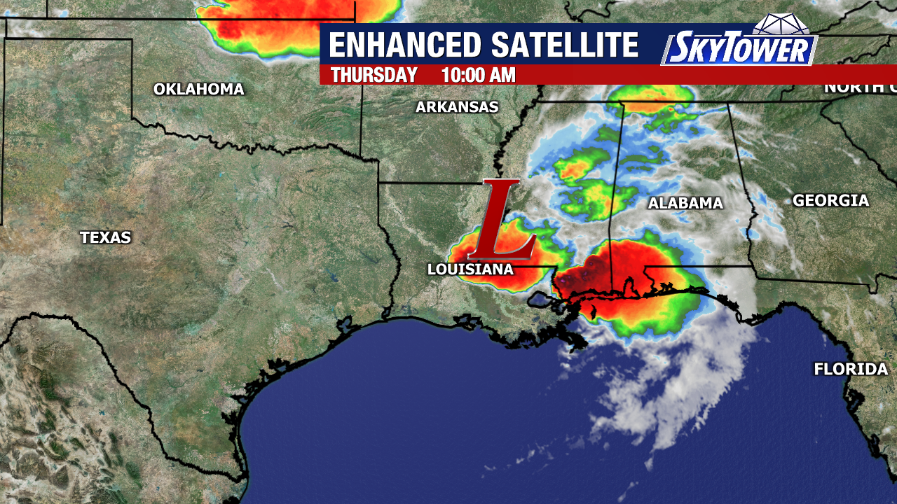
Analysis of GOES satellite loop imagery indicates shower and thunderstorm activity over Mississippi and Alabama. The remnant low appears to now be centered near the MS / AL line.
GOES 19 GULF SATELLITE LOOP (LINKED)

SE RADAR LOOP (LINKED)
The NHC currently indicates a LOW (10%) probability of Tropical Cyclone formation from the remnants of ARTHUR during the next 7 days off the U.S. east coast near the Mid Atlantic area of VA / NC.
NHC 7 DAY GTWO (LINKED TO OUTLOOK)
The ECMWF Cyclone Formation Probability forecast is indicating an 80% probability for cyclone development between 24 – 72 hours out from the 00Z run, as well as an 80% probability for Tropical Storm formation
ECMWF EPS CYCLONE FORMATION PROBABILITY 

Models indicate by early Fri. evening, the remnant low will emerge into the Mid Atlantic area over the Atlantic, developing a 1000 mb low pressure system. Analysis of forecast wind shear indicates although shear values are forecast at around 20 – 35 kts, the forecast indicates a “radial” pattern over the top of the low. This is different from “zonal” wind shear (shear from east to west, or west to east). If you think about how the radial patter looks, shear is basically moving away from the center of the system in an anti-cyclonic action, basically negating shear. This is favorable for development of tropical systems. The forecast indicates marginal divergence at the 200 mb level, which should provide limited outflow. Surface to mid level moisture is forecast to be favorable. Based on these forecast conditions, and analysis of forecast surface winds being further away from the center, I cannot rule out the remnants of ARTHUR re-developing into most likely a sub-tropical system either late Fri. or early Sat. This is going to be another wait and see scenario, as this all depends on EXACTLY how conditions come to fruition.
From the NHC Tropical Weather discussion:
Regardless of development, heavy rainfall with the potential for
widespread and life-threatening flash flooding is likely across
portions of the Southeast United States during the next day or two.
EXCESSIVE RAINFALL OUTLOOK (LINKED)
WPC 7 DAY PRECIPITATION FORECAST
ECMWF MSLP ANOMALIES FORECAST ANIMATION (36 HOURS)
ECMWF WIND SHEAR FORECAST(BLACK CIRCLE REPRESENTS FORECAST LOW), 200 MB STREAMLINE, 700 MB RELATIVE HUMIDITY, AND PRECIPITABLE WATER FORECAST 


Please click on the following map to access the current statements, advisories and warnings from the NWS. Once you click the map, click on your area of interest.
NWS WATCH / WARNING DISPLAY (LINKED…CLICK MAP, THEN YOUR AREA)
NWS DOPPLER RADAR LOOP (LINKED, CLICK RADAR MAP)
RAP RADAR (CLICK IMAGE THEN GO TO LOOP DURATION AND PICK LENGTH OF LOOP, THEN CLICK RADAR SITE)
WUNDERGROUND RADAR SUMMARY MAP (CLICK FOR UPDATES)
PRECIPITATION TYPE (CLICK TO ACCESS ANIMATION FEATURE)
CARIBBEAN RADAR (CLICK IMAGE TO ACCESS ANIMATION)
Elsewhere, I do not expect tropical cyclone formation for the next 5 – 7 days.
I will continue to monitor the tropics for any significant changes
Have a blessed evening!
T. F. “STORM” WALSH III
GMCS, USCG (ret)
METEOROLOGIST / HURRICANE SPECIALIST / SEVERE WEATHER SPECIALIST
CoCoRAHS OBSERVER


 English (US) ·
  French (CA) ·