
 4 hours ago
3
4 hours ago
3
PROTECT YOUR DNA WITH QUANTUM TECHNOLOGY
Orgo-Life the new way to the future Advertising by AdpathwayDisclaimer: This site is not affiliated with the National Hurricane Center, Hurricane Hunters, Storm Prediction Center, or National Weather Service. ALL forecasts herein are the result of my analysis, (to which you will see me at times, insert excerpts from various agencies due to the nature of the importance of the information) and I am solely responsible for the content. As ALWAYS, follow the National Hurricane Center, National Weather Service, and your local Emergency Management officials for emergency decisions. In addition, this is strictly a FORECAST OFFICE. I CANNOT make decisions regarding travel plans, etc. My purpose, is to provide you the information, based solely on information I analyze, and the accuracy of the information at hand of the time of analysis, so you may make informed decisions.
(T. F. “Storm” Walsh)
For those who have donated to my site, your help has been greatly appreciated. If you are not aware, donations to my site help pay for subscriptions to sites I use as well as software updates, which provide all the models and information used in my forecasts. To donate, please click the DONATE button to the right side of the page, or on the graphic of the dog. Any help you provide is immensely appreciated!
DONATIONS ACCEPTED AND APPRECIATED


I will reiterate, my forecasts are based on the available information at the time of analysis, and are only as accurate as the information analyzed and the solutions provided.
Good day everyone!
The following changes are being made. The forecast center is still closed on Sunday, and will be closed on Saturday as well (unless there is a threat from a tropical system). Please refer to the Storm Prediction Center for severe weather information.
SPC LINK
https://www.spc.noaa.gov/
Regarding the issuance of Tropical Weather Outlooks or Tropical Storm / Hurricane forecasts versus Severe Weather forecasts, IF Cyclone Formation Probability models become consistent in probability indicating possible development, or a probability is shown in the NHC GTWO (Graphical Tropical Weather Outlook) or a tropical system becomes a threat to the Caribbean islands, Mexico or any portion of the U.S. or becomes a constant entity in the Atlantic, Caribbean, or Gulf during any forecast of severe weather, the tropical weather forecast will take precedence. These may be lengthy, however I want to always give a full perspective on the tropics.
STORM W SEASONAL FORECAST
TOTAL NAMED STORMS: 9 – 12
TOTAL HURRICANES : 4 – 5
MAJOR HURRICANES: 1 – 2
AVERAGE HURRICANE SEASON:
TOTAL NAMED STORMS: 14
TOTAL HURRICANES: 7
MAJOR HURRICANES: 3
CSU (Dr. Phil Klotzbach) SEASONAL FORECAST
TOTAL NAMED STORMS: 11
TOTAL HURRICANES: 5
MAJOR HURRICANES: 2
WEATHERBELL (Chief Forecaster Joe Bastardi)
TOTAL NAMED STORMS: 9 – 13
TOTAL HURRICANES: 3 – 5
MAJOR HURRICANES: 1 – 2
2026 SEASON TOTALS
TOTAL NAMED STORMS: 1
TOTAL HURRICANES: 0
MAJOR HURRICANES: 0
The following is the list of storm names for the 2026 Atlantic Hurricane Season. Storm names will be marked in RED for active and already named systems:
Arthur Bertha Cristobal Dolly Edouard Fay Gonzalo Hanna Isaias
Josephine Kyle Leah Marco Nana Omar Paulette Rene Sally Teddy Vicky
Wilfred
GOES 19 ATLANTIC IR AND WV SATELLITE LOOP

Satellite loop imagery indicates the Atlantic remains quiet, with water vapor imagery indicating quite a bit of dry air in the Atlantic basin.
The NHC in the 06Z Surface Analysis indicated tropical waves near 21W, 37W, 68W and 77W
CIMSS 06Z TPW MAP (WAVE AXIS’ ARE IN BLACK)
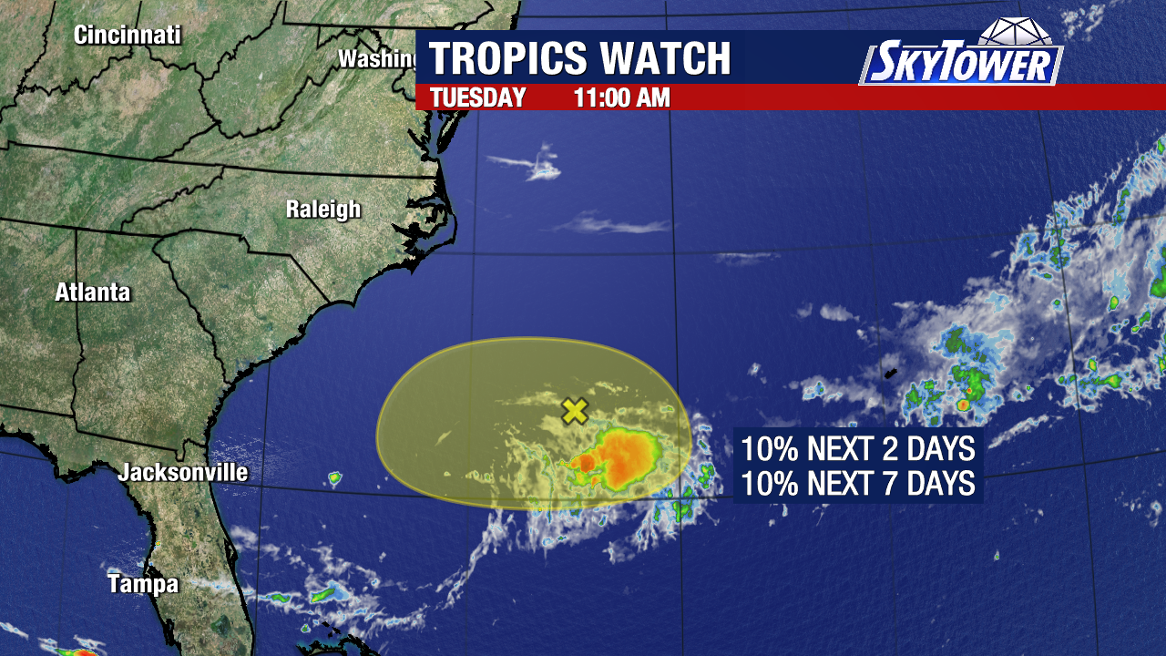
Satellite loop imagery indicates an area of disorganized showers and thunderstorms associated with a broad area of low pressure SE of NC / SC.
SEUS IR, VIS, AND WV SATELLITE LOOP


The NHC still indicates a LOW (10%) probability for tropical cyclone development during the next 7 days.
NHC 7 DAY GTWO (LINKED TO OUTLOOK)
The current ECMWF Cyclone Formation Probability forecast from 00Z still indicates the probability for cyclone development at 90% – 95% during the next 72 hours. Quite the discrepancy from the NHC probability.
ECMWF EPS CYCLONE FORMATION PROBABILITY 

Based on my analysis this morning, the center of the broad area of low pressure was located at approximately 31.8N;71.9W. Conditions are now beginning to turn unfavorable for development. Although the global models are a little off in timing, indicating a little more favorable environment this morning. However, water vapor satellite loop imagery indicates dry air ingestion by the low at the mid levels of the atmosphere, while analysis of various other maps indicate shear beginning to increase, lack of surface convergence and lack of upper level divergence. Models do however indicate that in approximately 24 – 30 hours, conditions will become unfavorable for any further development, with increasing wind shear values, and much drier air at the mid level of the atmosphere. In addition, the low is still attached to the frontal boundary, and based on this, it would not be able to become classified. This is what has me perplexed as to WHY the probability models are indicating such a high probability for a Tropical Depression.
Based on current, and forecast conditions if accurate, I am not expecting further development of this low, unless for some reason conditions take a drastic change, and I have to concur with the NHC probability for development.
As far as forecast motion, the current steering layer is now indicates a SSW motion and between the flow, and the trough to the east, is imparting a southward motion of the low, with the forecast calling for the steering currents to shift to a more WSW motion in about the 24 – 30 hour timeframe from 00Z yesterday evening.
CURRENT AND FORECAST STEERING

ECMWF WIND SHEAR, MID LEVEL HUMIDITY, AND PRECIPITABLE WATER FORECAST FORECAST 00Z (36 HOURS)


I will continue to monitor this area for any significant changes in the forecast.
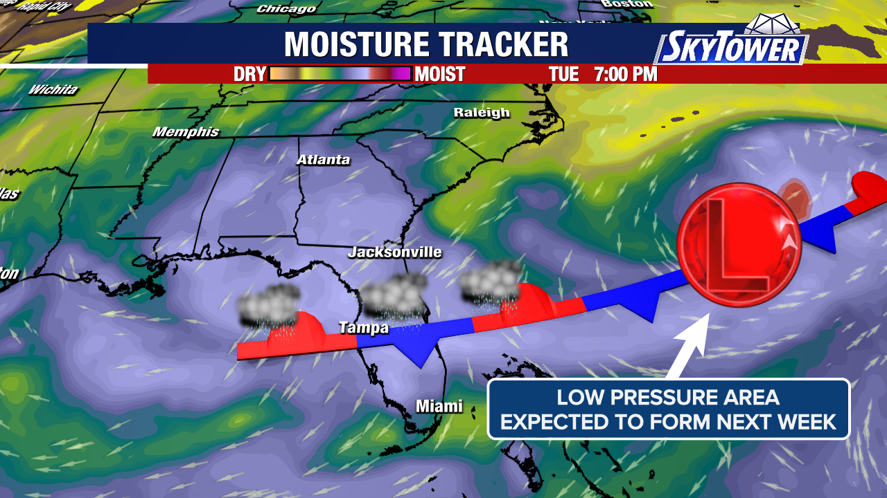
Elsewhere, I do not expect tropical cyclone formation during the next 5 – 7 days
Please click on the following map to access the current statements, advisories and warnings from the NWS. Once you click the map, click on your area of interest
NWS WATCH / WARNING DISPLAY (LINKED…CLICK MAP, THEN YOUR AREA)
NWS DOPPLER RADAR LOOP (LINKED, CLICK RADAR MAP)
RAP RADAR (CLICK IMAGE THEN GO TO LOOP DURATION AND PICK LENGTH OF LOOP, THEN CLICK RADAR SITE)
WUNDERGROUND RADAR SUMMARY MAP (CLICK FOR UPDATES)
PRECIPITATION TYPE (CLICK TO ACCESS ANIMATION FEATURE)
CARIBBEAN RADAR (CLICK IMAGE TO ACCESS ANIMATION)
You may direct any questions by contacting me personally, ANYTIME, at: [email protected]
Have a blessed day!
T. F. “STORM” WALSH III
GMCS, USCG (ret)
METEOROLOGIST / HURRICANE SPECIALIST / SEVERE WEATHER SPECIALIST
CoCoRAHS OBSERVE


 English (US) ·
  French (CA) ·