

 2 months ago
93
2 months ago
93
PROTECT YOUR DNA WITH QUANTUM TECHNOLOGY
Orgo-Life the new way to the future Advertising by AdpathwayDisclaimer: This site is not affiliated with the National Hurricane Center, Hurricane Hunters, Storm Prediction Center, or National Weather Service. ALL forecasts herein are the result of my analysis, (to which you will see me at times, insert excerpts from various agencies due to the nature of the importance of the information) and I am solely responsible for the content. As ALWAYS, follow the National Hurricane Center, National Weather Service, and your local Emergency Management officials for emergency decisions. In addition, this is strictly a FORECAST OFFICE. I CANNOT make decisions regarding travel plans, etc. My purpose, is to provide you the information, based solely on information I analyze, and the accuracy of the information at hand of the time of analysis, so you may make informed decisions.
(T. F. “Storm” Walsh)
For those who have donated to my site, your help has been greatly appreciated. If you are not aware, donations to my site help pay for subscriptions to sites I use as well as software updates, which provide all the models and information used in my forecasts. To donate, please click the DONATE button to the right side of the page, or on the graphic of the dog. Any help you provide is immensely appreciated!
DONATIONS ACCEPTED AND APPRECIATED


I will reiterate, my forecasts are based on the available information at the time of analysis, and are only as accurate as the information analyzed and the solutions provided.
Good day everyone!
I leave for PA. tomorrow to visit my youngest son. I will resume forecasting on Aug. 3, and will work my forecasts around my future medical appointments. Though the office will be closed, we should not see anything after Bertha, as the MJO is forecast to cycle into the “null” or neutral phase, and eventually into phase 6. Phases 8, 1, 2, and 3 are the favorable phases for development in our basins, with phases 1 and 2 being the most favorable.
The following changes are being made. The forecast center is still closed on Sunday, and will be closed on Saturday as well (unless there is a threat from a tropical system). Please refer to the Storm Prediction Center for severe weather information.
SPC LINK
https://www.spc.noaa.gov/
Regarding the issuance of Tropical Weather Outlooks or Tropical Storm / Hurricane forecasts versus Severe Weather forecasts, IF Cyclone Formation Probability models become consistent in probability indicating possible development, or a probability is shown in the NHC GTWO (Graphical Tropical Weather Outlook) or a tropical system becomes a threat to the Caribbean islands, Mexico or any portion of the U.S. or becomes a constant entity in the Atlantic, Caribbean, or Gulf during any forecast of severe weather, the tropical weather forecast will take precedence. These may be lengthy, however I want to always give a full perspective on the tropics.
2026 SEASON TOTALS
TOTAL NAMED STORMS: 2
TOTAL HURRICANES: 0
MAJOR HURRICANES: 0
The following is the list of storm names for the 2026 Atlantic Hurricane Season:
Arthur Bertha Cristobal Dolly Edouard Fay Gonzalo Hanna Isaias
Josephine Kyle Leah Marco Nana Omar Paulette Rene Sally Teddy Vicky
Wilfred
The NHC is issuing advisories on Tropical Depression number 2
NHC 7 DAY GTWO (LINKED TO OUTLOOK)
The following is Tropical Storm BERTHA satellite loop imagery:
BERTHA IR, WATER VAPOR AND VISIBLE LOOP IMAGERY


As of the 11:00 a.m. EDT (10:00 a.m. CDT) advisory from the NHC, the following was available on T. S.BERTHA
11:00 AM EDT Tue Jul 21
Location: 29.3°N; 86.3°W
Moving: NNW 3 mph
Min pressure: 995 mb / 29.38 in.
Max sustained: 60 mph
WATCHES AND WARNINGS
——————–
CHANGES WITH THIS ADVISORY:
The Tropical Storm Watch has been upgraded to a Tropical Storm
Warning from the Florida/Alabama border eastward to the Bay/Gulf
County Line.
The Tropical Storm Warning has been extended westward to the
Terrebonne/Lafourche Parish Line.
The Tropical Storm Watch has been extended westward from Morgan
City, Louisiana, to the Vermilion/Cameron Parish Line.
The Storm Surge Watch has been discontinued along the northern Gulf
Coast. A Coastal Flood Warning has been issued by the National
Weather Service for portions of the southeastern Louisiana and
Mississippi coastline.
SUMMARY OF WATCHES AND WARNINGS IN EFFECT:
A Tropical Storm Warning is in effect for…
* Bay/Gulf County Line in Florida to the Terrebonne/Lafourche Parish
Line in Louisiana
A Tropical Storm Watch is in effect for…
* West of the Terrebonne/Lafourche Parish Line to the
Vermilion/Cameron Parish Line
* Metropolitan New Orleans, Lake Pontchartrain, and Lake Maurepas
A Tropical Storm Warning means that tropical storm conditions are
expected somewhere within the warning area within 36 hours.
A Tropical Storm Watch means that tropical storm conditions are For storm information specific to your area, including other
possible within the watch area, in this case in the next 24 to 48
hours.
coastal and inland watches and warnings, please monitor products
issued by your local National Weather Service forecast office.
NHC PUBLIC ADVISORY LINK
https://www.nhc.noaa.gov/text/refresh/MIATCPAT2+shtml/211454.shtml?
ADVISO PUBLICO
https://www.nhc.noaa.gov/text/refresh/MIATASAT2+shtml/211456.shtml?
NHC LOCAL PRODUCTS FOR TROPICAL DEPRESSION 2
https://www.nhc.noaa.gov/text/refresh/index_hls_at2+shtml/211509.shtml?
KEY MESSAGES (LINKED)

Based on current steering, the storm is currently in between 2 high pressure ridges, which is causing steering currents to remain weak, hence the slow forward motion. Based on analysis of forecast steering currents, the setup calls for the subtropical ridge to pretty much remain in place with only a little shifting between west and east. The ridge to Bertha’s west is forecast to slowly move toward the W during the next 48 hours. This will allow for a weakness to develop, which the depression should slowly move through. Based on this, I tend to agree with the NHC forecast track and prefer the current HFWI Hurricane Weather Research model and TVCN new track (in red)
NHC FORECAST TRACKING MAP
RAL 12Z T. S. BERTHA TRACK GUIDANCE (CLICK FOR LARGER IMAGE)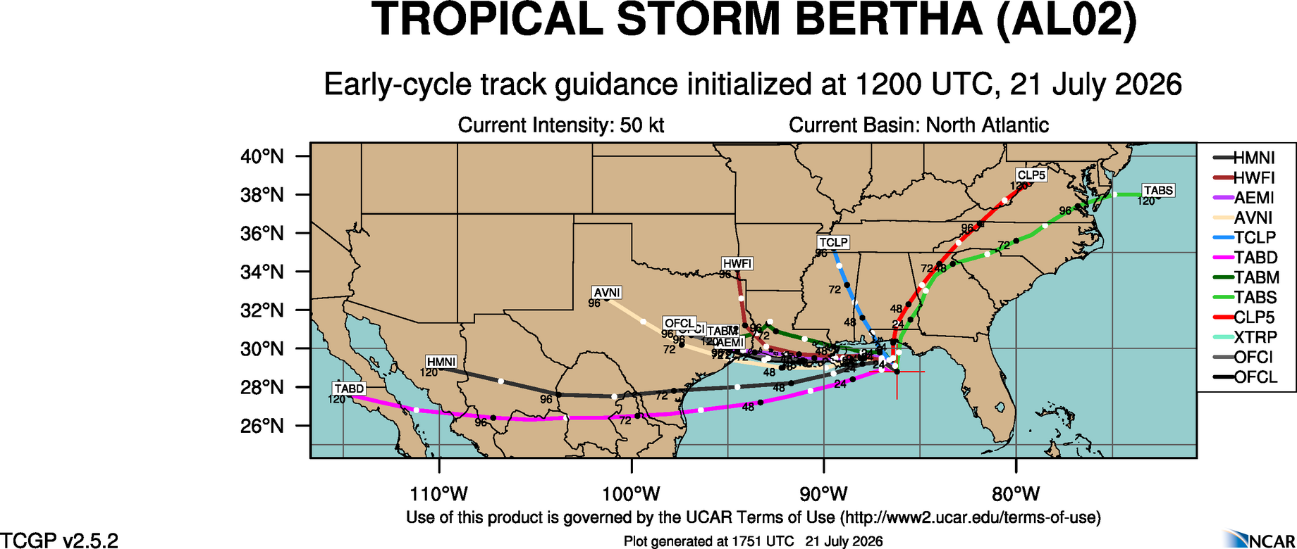
TVCN TRACK TREND (CURRENT FORECAST IN RED)
The system was still under NELY wind shear which has increased in intensity, which has tilted the circulation / convection. Upper level winds are pretty much zonal, however you can see the wind barbs “fan out” slightly. This is allowing for some minimal divergence from the south edge of the circulation center, southward, noted in yellow.
CIMSS CURRENT WIND SHEAR 
CURRENT UPPER LEVEL WIND MAP
Well, the NHC does it again, and I have to disagree with the naming of this system. The criteria for a Tropical Cyclone is as follows:
A warm-core non-frontal synoptic-scale cyclone, originating over tropical or subtropical waters, with organized deep convection and a closed surface wind circulation about a well-defined center. Once formed, a tropical cyclone is maintained by the extraction of heat energy from the ocean at high temperature and heat export at the low temperatures of the upper troposphere. In this they differ from extratropical cyclones, which derive their energy from horizontal temperature contrasts in the atmosphere (baroclinic effects).
The NHC credits the slow strengthening of the system to continued bursts of convection, vice ORGANIZED DEEP CONVECTION in the 10:00 a.m. forecast discussion from yesterday:
The depression is experiencing moderate northeasterly shear, and these conditions should continue for another 24-30 h. It is likely that there will be convective bursts near and south of the center during this time, and these should help intensify the cyclone to a tropical storm.
I rest my case.
Based on my analysis of current and forecast wind shear, 200 mb streamlines as well as surface moisture (PWAT) and mid level relative humidity values, models indicate wind shear to remain in place and is forecast to increase by tonight. Water vapor imagery indicates some dry air intrusion, and models indicate an increase in drier air in the mid levels during the next 48 hours. Recent satellite loop imagery does however indicate a deep burst of convection almost directly over the center at the moment. Whether this persists or not is unknown. Though I disagree with the designation, this may be the time in the forecast, that this current burst of convection, according to the NHC could possibly push the system to the 60 mph forecast intensity, which has now occurred in the NHC 11:00 a.m. update.
ECMWF EPS WIND SHEAR FORECAST
Based on the forecast from the global models however, if forecast conditions actually happen, along with the recent SHIPS diagnostic report, further intensification should not occur.
RAL 12Z INTENSITY GUIDANCE
NHC FORECAST POSITIONS AND MAX WINDS
INIT 21/1500Z 29.3N 86.3W 50 KT 60 MPH
12H 22/0000Z 29.4N 87.0W 50 KT 60 MPH
24H 22/1200Z 29.5N 88.0W 45 KT 50 MPH
36H 23/0000Z 29.4N 89.5W 40 KT 45 MPH…NEAR THE COAST
48H 23/1200Z 29.3N 91.3W 35 KT 40 MPH…NEAR THE COAST
60H 24/0000Z 29.4N 93.1W 30 KT 35 MPH…OVER WATER
72H 24/1200Z 29.9N 94.9W 25 KT 30 MPH…INLAND
96H 25/1200Z 31.0N 97.5W 20 KT 25 MPH…POST-TROP/INLAND
120H 26/1200Z…DISSIPATED
RAP RADAR ANIMATION (LINKED) CLICK FOR ANIMATION
The following graphics are from the NHC and HURRTRACK APP
WATCHES / WARNINGS
5 DAY RAINFALL FORECAST
RIP CURRENTS COMPOSITE FORECAST

Elsewhere, Tropical Storm formation is not expected during the next 5 – 7 days.
The following links will connect you to the Excessive Rainfall probabilities and River Flood Outlook:
EXCESSIVE RAINFALL
https://www.wpc.ncep.noaa.gov/qpf/excessive_rainfall_outlook_ero.php
SIGNIFICANT RIVER FLOOD OUTLOOK
https://www.wpc.ncep.noaa.gov/nationalfloodoutlook/index.html
Please click on the following map to access the current statements, advisories and warnings from the NWS. Once you click the map, click on your area of interest.
NWS WATCH / WARNING DISPLAY (LINKED…CLICK MAP, THEN YOUR AREA)
NWS DOPPLER RADAR LOOP (LINKED, CLICK RADAR MAP)
RAP RADAR (CLICK IMAGE THEN GO TO LOOP DURATION AND PICK LENGTH OF LOOP, THEN CLICK RADAR SITE)
WUNDERGROUND RADAR SUMMARY MAP (CLICK FOR UPDATES)
PRECIPITATION TYPE (CLICK TO ACCESS ANIMATION FEATURE
CARIBBEAN RADAR (CLICK IMAGE TO ACCESS ANIMATION)
Have a blessed day!
T. F. “STORM” WALSH III
GMCS, USCG (ret)
METEOROLOGIST / HURRICANE SPECIALIST / SEVERE WEATHER SPECIALIST
CoCoRAHS OBSERVER

















 English (US) ·
  French (CA) ·