
 1 month ago
88
1 month ago
88
PROTECT YOUR DNA WITH QUANTUM TECHNOLOGY
Orgo-Life the new way to the future Advertising by AdpathwayDisclaimer: This site is not affiliated with the National Hurricane Center, Hurricane Hunters, Storm Prediction Center, or National Weather Service. ALL forecasts herein are the result of my analysis, (to which you will see me at times, insert excerpts from various agencies due to the nature of the importance of the information) and I am solely responsible for the content. As ALWAYS, follow the National Hurricane Center, National Weather Service, and your local Emergency Management officials for emergency decisions. In addition, this is strictly a FORECAST OFFICE. I CANNOT make decisions regarding travel plans, etc. My purpose, is to provide you the information, based solely on information I analyze, and the accuracy of the information at hand of the time of analysis, so you may make informed decisions.
(T. F. “Storm” Walsh)
For those who have donated to my site, your help has been greatly appreciated. If you are not aware, donations to my site help pay for subscriptions to sites I use as well as software updates, which provide all the models and information used in my forecasts. To donate, please click the DONATE button to the right side of the page, or on the graphic of the dog. Any help you provide is immensely appreciated!
DONATIONS ACCEPTED AND APPRECIATED


I will reiterate, my forecasts are based on the available information at the time of analysis, and are only as accurate as the information analyzed and the solutions provided.
Good evening everyone!
The following changes are being made. The forecast center is still closed on Sunday, and will be closed on Saturday as well (unless there is a threat from a tropical system, or a severe weather threat of a SLIGHT risk or above).
Regarding Tropical Weather Outlook issuance and Tropical Storm / Hurricane forecasts versus Severe Weather forecasts, IF a tropical system becomes a threat to the Caribbean islands, Mexico or any portion of the U.S. or becomes a constant entity in the Atlantic, Caribbean, or Gulf during any forecast of severe weather, the tropical system will take precedence. These may be lengthy, however I want to always give a full perspective on the tropics.
STORM W SEASONAL FORECAST
TOTAL NAMED STORMS: 10 – 13
TOTAL HURRICANES : 4 – 6
MAJOR HURRICANES: 1 – 3
AVERAGE HURRICANE SEASON:
TOTAL NAMED STORMS: 14
TOTAL HURRICANES: 7
MAJOR HURRICANES: 3
CSU (Dr. Phil Klotzbach) SEASONAL FORECAST
TOTAL NAMED STORMS: 13
TOTAL HURRICANES: 6
MAJOR HURRICANES: 2
WEATHERBELL (Chief Forecaster Joe Bastardi)
TOTAL NAMED STORMS: 9 – 13
TOTAL HURRICANES: 3 – 5
MAJOR HURRICANES: 1 – 2
The following is the list of storm names for the 2026 Atlantic Hurricane Season:
Arthur Bertha Cristobal Dolly Edouard Fay Gonzalo Hanna Isaias
Josephine Kyle Leah Marco Nana Omar Paulette Rene Sally Teddy Vicky
Wilfred
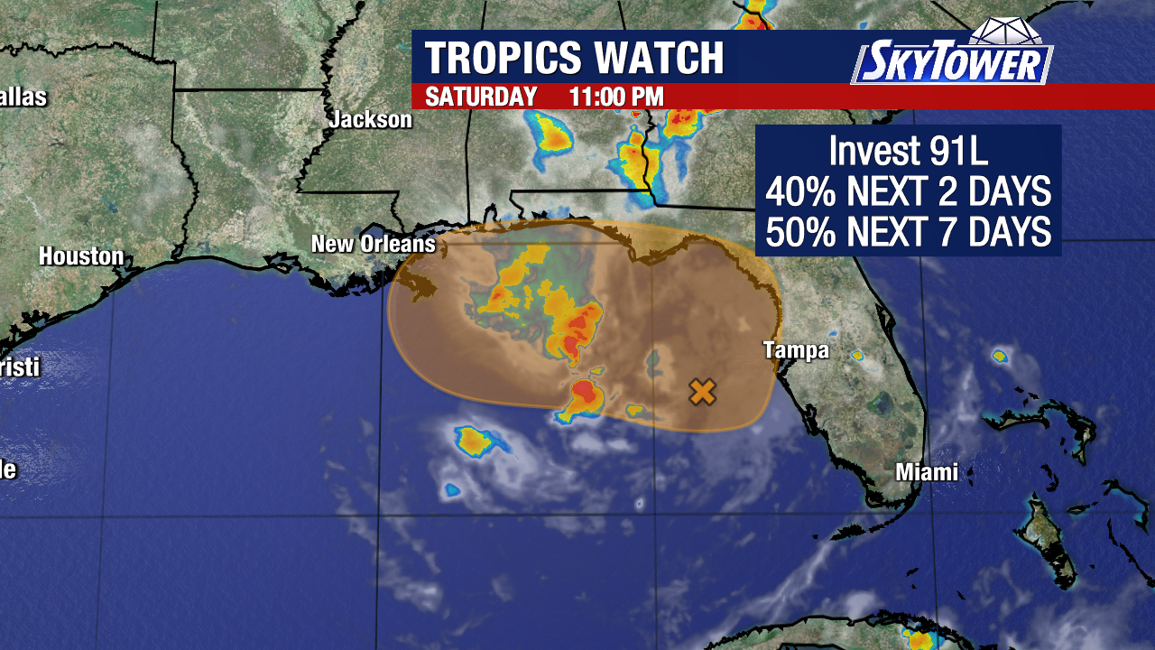
Analysis of GOES satellite loop imagery indicates a disorganized area of showers and thunderstorms in the Gulf, which appears to be the beginning of weak low pressure which is now in the forecast. From the NHC Tropical Weather Discussion: Strong to near- gale force wind are possible on the northern end of the trough over the north-central Gulf starting tonight as the low pressure forms.
GOES 19 IR SATELLITE LOOP (LINKED)
GOES 19 VISIBLE LOOP
The NHC does not indicate any development during the next 7 days
NHC 7 DAY GTWO (LINKED)
The ECMWF Cyclone Formation Probability forecast indicates a 15% probability for development from the 12Z run during the next 24 – 72 hours.
ECMWF EPS CYCLONE FORMATION PROBABILITY 
All three global models are in agreement of lowering MSLP in the Gulf within the next 24 – 36 hours, with the ECMWF being consistent for the past 2 days.
ECMWF MSLP ANOMALIES FORECAST (24 – 72 HOURS)
Based on analysis of forecast wind shear, mid level moisture, and surface moisture, most of the surface moisture is just east of the area, and wind shear is forecast to remain high. Based on this, I do not expect development of this area during the next 3 days. However, the increase in moisture will allow for some isolated minor flooding over eastern Louisiana due to an increase in precipitation, and possible minor coastal flooding. Currently, the ECMWF indicates winds of around 25 – 30 mph close to or on the coast with gusts to minimal tropical storm force. The NWS has issued a COASTAL FLOOD advisory, a SMALL CRAFT advisory, and RIP CURRENT statement for portions of the Louisiana coast. Please click the NWS WATCH / WARNING MAP to access advisories.
ECMWF WIND SPEED AND GUSTS FORECAST

Seas could reach 7 – 9 ft near the immediate coast
ECMWF WAVE WATCH FORECAST
WPC 5 DAY PRECIPITATION TOTAL FORECAST
ECMWF WIND SHEAR FORECAST, 700 MB RELATIVE HUMIDITY, AND PRECIPITABLE WATER


NWS WATCH / WARNING DISPLAY (LINKED…CLICK MAP, THEN YOUR AREA)
Looking further into things, models are hinting at development in about 10 – 12 days in the Gulf, with the ECMWF and GFS showing consistency so far, with the ECMWF EPS probability at 25%. Given this is past the 7 day forecast period, this should not be considered accurate at the moment, and I will be monitoring the situation closely.
I do not expect tropical storm formation during the next 5 – 7 days. I will continue to monitor the tropics for any significant changes
Have a blessed evening!
T. F. “STORM” WALSH III
GMCS, USCG (ret)
METEOROLOGIST / HURRICANE SPECIALIST / SEVERE WEATHER SPECIALIST
CoCoRAHS OBSERVER


 English (US) ·
  French (CA) ·